
Arctic Blast Forecast to Hit Midwest, Great Plains, and Central U.S. Next Weekend Bringing Frigid Temperatures and Below-Normal Conditions
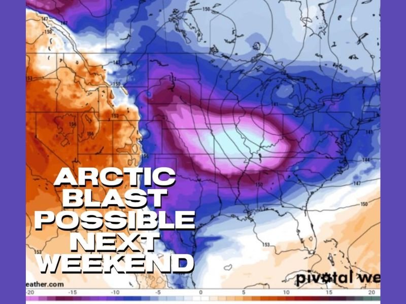
ILLINOIS — Meteorologists are tracking a powerful Arctic blast expected to surge into the Midwest, Great Plains, and Central United States next weekend, delivering some of the coldest air of the season so far. Forecast models show temperatures plunging 20 to 30 degrees below normal, with the potential for subfreezing conditions spreading as far south as Oklahoma and northern Texas.
Sharp Temperature Drop Expected Across Central U.S.
Early model projections indicate a massive dome of Arctic air pushing south from Canada late next week, expanding rapidly across the northern and central states. By Saturday, the cold front is expected to stretch from the Dakotas and Nebraska into Iowa, Illinois, Missouri, and Kansas, before spilling eastward toward the Ohio Valley by Sunday.
The latest temperature anomaly maps reveal an intense pocket of cold air centered over the central Midwest, where departures from average could reach 35 to 40 degrees below seasonal norms. Cities such as Minneapolis, Des Moines, Kansas City, and Chicago are forecast to experience morning lows in the single digits with wind chills below zero. Daytime highs could remain in the teens or low 20s through much of next weekend.
Impacts Across the Midwest and Great Plains
The National Weather Service warns that this upcoming Arctic event could cause dangerous wind chills and localized travel disruptions as frost and ice develop on untreated roads. Residents in the Great Plains, including Nebraska and South Dakota, are expected to see the first surge of bitter air by Thursday night before it spreads eastward.
For Illinois residents, including those in Naperville and the Chicago metro area, the cold will intensify by next weekend. Daytime highs are projected to stay near 20°F, while overnight lows could fall into the single digits, with wind chills possibly dipping below zero. The region may also see light snow or flurries as cold air interacts with lingering moisture.
Pattern to Continue Into Following Week
Forecasters note that the cold pattern may not end quickly. Long-range outlooks suggest repeated Arctic surges could continue for 10 to 15 days, keeping temperatures well below average across the central and eastern United States. This pattern could also set the stage for potential snow systems, depending on how the jet stream interacts with Gulf moisture later in the month.
Meteorologists describe the upcoming event as a “true Arctic outbreak,” typical of mid-winter rather than early December. Energy demand is expected to spike as heating usage increases sharply across the Midwest and Plains.
Preparation and Safety Measures
Residents are urged to prepare for the extreme cold by checking furnaces, insulating pipes, and protecting outdoor pets and plants. Travelers should monitor weather updates closely, as temperature swings could cause icy road conditions and mechanical issues for vehicles exposed to prolonged cold.
Local utilities and emergency managers recommend keeping extra blankets, flashlights, and backup heat sources available in case of power interruptions. Farmers and ranchers across the Plains should take precautions to safeguard livestock from wind chill exposure.
As the Arctic front approaches, updated forecasts will refine exact timing and temperature impacts across the region. For ongoing coverage, local advisories, and Midwest weather updates, visit NapervilleLocal.com for the latest information.

I’ve lived in Naperville long enough to see how quickly our community changes — from new developments downtown to sudden shifts in our Midwest weather. Reporting on Naperville news and daily forecasts gives me the chance to keep neighbors informed about what really matters. My goal is simple: deliver clear, timely updates so you always know what’s happening in our city and what to expect from the skies above.