
Illinois and Iowa Upgraded to Winter Storm Warnings as Snow Totals Rise to 6 Inches in Some Areas
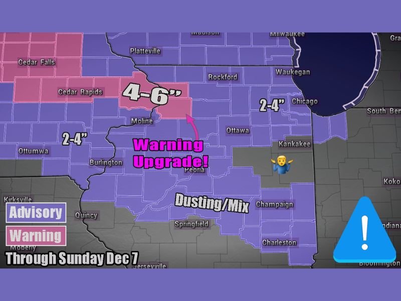
ILLINOIS — The National Weather Service has upgraded portions of Illinois and Iowa from Winter Weather Advisories to Winter Storm Warnings as forecasters now expect higher snowfall totals through Sunday, December 7. A fast-moving clipper system is producing bands of moderate to heavy snow, with some areas likely to receive 4 to 6 inches before the storm tapers off.
Upgraded Alerts for Central and Eastern Iowa into Northern Illinois
As of Saturday evening, meteorologists confirmed that enhanced snow bands forming along the storm track are leading to increased accumulations across portions of eastern Iowa and northwestern Illinois. Cities such as Cedar Rapids, Moline, and Davenport are now under Winter Storm Warnings, with totals reaching 4 to 6 inches in localized spots.
Farther east into northern Illinois, including Rockford, Chicago, and Kankakee, totals are expected to range between 2 and 4 inches, depending on where the heaviest bands develop. Meanwhile, areas of central and east-central Illinois, including Champaign and Springfield, could see only a dusting to an inch of snow mixed with sleet or freezing drizzle at times.
Forecasters describe this as “classic clipper behavior,” with enhanced snow production occurring in narrow, fast-moving bands. The result is sharp differences in snowfall totals over short distances, meaning one county could receive several inches more than the next.
Travel Impacts and Timing
The most intense snowfall is expected from Saturday night through early Sunday morning, gradually tapering by mid-afternoon Sunday. Roads will likely become slick and snow-covered, especially across north-central Illinois and eastern Iowa, where accumulation rates may briefly exceed one inch per hour.
Drivers using major routes such as Interstate 80, I-88, and I-74 should expect reduced visibility, slippery stretches, and possible delays. Plow crews are already mobilized in northern counties, but gusty winds could still cause blowing and drifting snow, particularly in open rural areas.
The Illinois Department of Transportation urges travelers to reduce speeds, maintain safe following distances, and allow extra time for commutes or weekend trips.
Areas at Greatest Risk
- Eastern Iowa: Cedar Rapids, Davenport, and Burlington (4–6 inches possible)
- North-Central Illinois: Moline, Rockford, and DeKalb (2–4 inches)
- Chicago Metro Area: Light to moderate snow, 2–3 inches possible with slick roads
- Central Illinois: Peoria, Champaign, Springfield — dusting or light mix, minimal accumulation
Outlook After the System
Once the snow clears Sunday afternoon, temperatures will remain below freezing through Monday morning, ensuring slick surfaces linger into the start of the workweek. However, forecasters say no additional major storms are expected immediately after this system, offering a short reprieve before another cold front moves in midweek.
Residents are encouraged to stay alert for forecast updates as snow bands may shift, altering accumulation totals in localized areas. The National Weather Service continues to monitor radar data closely for any additional warning expansions.
For live storm coverage, regional advisories, and weather safety tips, visit NapervilleLocal.com for the latest updates across Illinois and Iowa.

I’ve lived in Naperville long enough to see how quickly our community changes — from new developments downtown to sudden shifts in our Midwest weather. Reporting on Naperville news and daily forecasts gives me the chance to keep neighbors informed about what really matters. My goal is simple: deliver clear, timely updates so you always know what’s happening in our city and what to expect from the skies above.