
Illinois, Iowa, and Wisconsin to See Accumulating Snow Tonight as Fast-Moving System Brings Up to Six Inches Across Midwest and Great Lakes
ILLINOIS — A quick-hitting winter system is sweeping out of the Northern Plains into the Midwest and Great Lakes tonight, delivering a fresh round of accumulating snow to parts of Illinois, Iowa, and Wisconsin. Forecasters say the storm will create slippery roads and reduced visibility across much of the region through early Monday morning.
Fast-Moving System Brings Widespread Snowfall
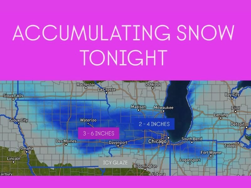
The system, typical of early December “clipper-style” storms, will move rapidly across the Upper Midwest overnight. A widespread 2 to 4 inches of snow is expected from Des Moines and Davenport eastward through Chicago, Rockford, and Milwaukee, while heavier bands may bring 3 to 6 inches in central Iowa and northwestern Illinois.
Light snow began earlier this evening across Iowa and southern Minnesota and will expand eastward into northern Illinois and southern Wisconsin by midnight. Meteorologists note that snow intensity may increase briefly in narrow bands, leading to quick accumulations and hazardous driving conditions, particularly along the Interstate 80 and I-90 corridors.
Slick Travel Expected Overnight and Monday Morning
As the snow spreads eastward, roads are expected to become snow-covered and icy, especially in untreated areas. Commuters heading out early Monday should anticipate slippery conditions and longer travel times across much of the Chicago metro area and surrounding suburbs.
In Iowa, Des Moines, Waterloo, and Cedar Rapids are expected to see moderate snow totals, while Chicago, Rockford, and Madison will likely pick up 2 to 4 inches by daybreak. The National Weather Service warns that an icy glaze could also develop in some areas where light freezing drizzle mixes in late tonight, particularly south of Interstate 80.
Temperature and Visibility Concerns
Temperatures will remain in the upper 20s to low 30s, cold enough for snow to accumulate efficiently. Gusty northwest winds behind the system could also cause blowing snow in open areas, reducing visibility for overnight travelers.
The snow will gradually taper off from west to east early Monday morning, but lingering flurries and icy patches are expected through the morning commute. By Monday afternoon, skies will clear with highs reaching only the upper 30s, keeping the region locked in a chilly pattern.
Outlook for the Week
Forecasters say this will be the first of several quick-moving snow systems tracking across the Midwest over the next 10 days. Another light round of snow is possible later in the week as colder air continues to dominate the region.
Residents are encouraged to monitor local forecasts, allow extra travel time, and prepare for slick conditions overnight. For live weather updates, snowfall reports, and regional travel alerts, visit NapervilleLocal.com for the latest coverage.

I’ve lived in Naperville long enough to see how quickly our community changes — from new developments downtown to sudden shifts in our Midwest weather. Reporting on Naperville news and daily forecasts gives me the chance to keep neighbors informed about what really matters. My goal is simple: deliver clear, timely updates so you always know what’s happening in our city and what to expect from the skies above.