
New York, Pennsylvania, and New England States to Face Extreme Cold Tuesday Morning With Temperatures Up to 30 Degrees Below Normal
NEW YORK, NEW YORK — A powerful Arctic air mass will plunge into New York, Pennsylvania, and the New England states early Tuesday morning, sending temperatures as much as 30 degrees below normal and bringing the coldest conditions of the season so far. Meteorologists warn that the widespread deep freeze will make morning wind chills dangerously cold across much of the Northeast.
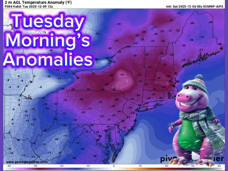
Deep Freeze Grips the Northeast
Forecast models show temperature anomalies ranging from –20°F to –32°F below average, centered over Pennsylvania, upstate New York, Vermont, and New Hampshire. Cities such as Buffalo, Albany, Scranton, and Boston are expected to see lows in the single digits and low teens, while interior mountain valleys may dip below zero.
The European weather model (ECMWF) projects the coldest readings across interior Pennsylvania and New York, where frigid Arctic air will settle overnight under clear skies. By sunrise, wind chills will range from –10°F to –25°F, especially in higher elevations and open areas.
Wind Chill Dangers and Regional Impacts
The National Weather Service cautions that frostbite can occur on exposed skin in as little as 30 minutes under these conditions. Residents across the Appalachians, Catskills, and Adirondacks should prepare for bitter wind chills and dangerously cold air through Tuesday morning.
Public utilities and local agencies are warning of possible power strain and frozen pipes as heating systems work at maximum capacity. Motorists are advised to check vehicles for antifreeze protection and ensure batteries are fully charged before traveling in the extreme cold.
Schools and outdoor programs in parts of Vermont, New Hampshire, and Maine may delay or limit outdoor activities due to the harsh temperatures.
Extended Cold Pattern Likely to Persist
Meteorologists say this Arctic blast will likely linger through the week, keeping temperatures 10 to 25 degrees below average through Friday. Although a slight moderation is possible by the weekend, another push of cold air is expected by mid-December, signaling a prolonged winter pattern across the northern United States.
Experts note that this event marks the first major deep freeze of December, ushering in what could be a colder-than-average month for the entire Northeast region.
Residents are urged to take precautions—wrap pipes, protect pets, and limit outdoor exposure during peak morning cold hours. For continuing updates on regional forecasts and safety alerts, visit NapervilleLocal.com for the latest coverage.

I’ve lived in Naperville long enough to see how quickly our community changes — from new developments downtown to sudden shifts in our Midwest weather. Reporting on Naperville news and daily forecasts gives me the chance to keep neighbors informed about what really matters. My goal is simple: deliver clear, timely updates so you always know what’s happening in our city and what to expect from the skies above.