
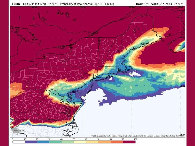
New York, Pennsylvania, and New Jersey to See Light Weekend Snowfall as Northeast Stays Mostly Dry
NEW YORK — Residents across New York, Pennsylvania, and New Jersey are in for a dusting of snow this weekend, but forecasters say the event will be light, brief, and largely unimpressive compared to what’s typical for mid-December. According to the European Centre for Medium-Range Weather Forecasts (ECMWF), most of the Northeast will see less than an inch of snow, with a 30% or lower chance of measurable accumulation in most areas.
Minor System Brings Little More Than Flurries
Meteorologists say this weak system will pass through the Mid-Atlantic and New England regions late Friday into Saturday, producing only spotty snow showers. Areas from northern Virginia up through southern Maine could experience brief flurries, but forecasts indicate that significant accumulation is unlikely.
The highest chance for a coating to an inch will be along coastal regions and higher elevations, including parts of northeastern Pennsylvania, the Catskills, and interior New York. Even there, however, the system lacks the strength and moisture typical of winter storms that usually sweep through this region by mid-December.
Temperatures Too Warm for Substantial Accumulation
While colder air will filter into the Northeast late in the weekend, forecasters note that ground temperatures remain too warm to support sustained snow cover. Daytime highs will stay in the upper 30s to low 40s, melting most of whatever snow manages to fall.
This mild setup contrasts sharply with the deep Arctic blast affecting much of the Central and Southern U.S. at the same time. The Northeast, by comparison, remains on the edge of the polar air mass, limiting snow potential despite seasonal chill.
Frustrating Forecast for Snow Lovers
Snow enthusiasts across the region may find this weekend’s outlook disappointing. December is usually a month when the first significant snowfalls blanket cities like Albany, Scranton, and Hartford, but so far, 2025’s pattern has offered little more than fleeting flurries.
“This is a weak signal — nothing that will deliver a real snow event,” forecasters said, describing the forecast as “pathetic” in terms of accumulation chances.
What’s Next for the Northeast
Looking ahead, meteorologists say no major snow systems are expected through mid-December. The long-range outlook continues to favor drier, milder conditions for much of the Northeast, with only short cold bursts rather than sustained wintry weather.
Residents across New York, Pennsylvania, and New Jersey should expect a light dusting at best, along with chilly winds that remind everyone winter has arrived — just not in full force yet.
Stay updated with regional weather developments and upcoming cold surges through NapervilleLocal.com.

I’ve lived in Naperville long enough to see how quickly our community changes — from new developments downtown to sudden shifts in our Midwest weather. Reporting on Naperville news and daily forecasts gives me the chance to keep neighbors informed about what really matters. My goal is simple: deliver clear, timely updates so you always know what’s happening in our city and what to expect from the skies above.