
Arctic Blast to Hit Illinois, Midwest, Great Lakes, and Ohio Valley With Temperatures Up to 40° Below Normal This Weekend
ILLINOIS — A powerful surge of Arctic air — expected to be the coldest of the season so far for many regions — is set to sweep into the Midwest, Great Lakes, and Ohio Valley this upcoming weekend, sending temperatures plunging far below seasonal averages and delivering dangerous cold across a large portion of the United States.
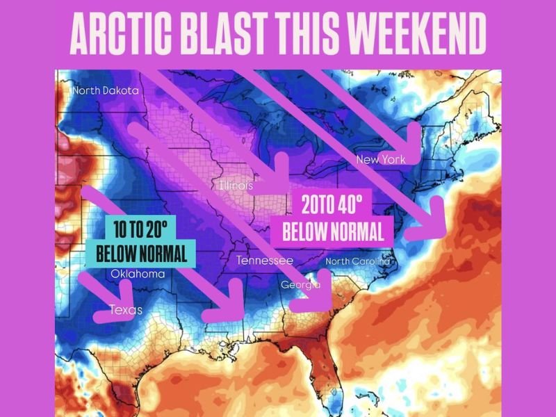
Forecasters warn that the Arctic outbreak will be intense and widespread, with some states experiencing temperature departures of 20 to 40 degrees below normal, while others in the Southern Plains may still see a sharp drop of 10 to 20 degrees below normal.
Deep Freeze Targets the Midwest, Great Lakes, and Ohio Valley
The coldest air associated with this system is expected to settle over:
- Illinois
- Indiana
- Ohio
- Michigan
- Wisconsin
- Minnesota
In these regions, temperatures will plummet up to 40 degrees below typical December norms, marking one of the most significant cold spells of the season. Wind chills may drop even lower, increasing the risk of frostbite and hypothermia for those spending extended time outdoors.
Eastern U.S. to Feel a Sharp Chill as Well
While the core of the Arctic blast concentrates on the central and northern United States, the East Coast will also experience notably colder conditions. States including New York, Pennsylvania, Virginia, North Carolina, and Georgia are forecast to feel a quick but forceful push of frigid air, leading to unusually chilly mornings and potentially icy travel conditions.
Southern Plains to See a Glancing but Notable Temperature Drop
Though not experiencing the worst of the Arctic air, states such as:
- Texas
- Oklahoma
- Arkansas
will still see temperatures settling 10 to 20 degrees below normal. This shift could create hazards for sensitive vegetation, outdoor pets, and unprotected water pipes — especially in areas unaccustomed to winter extremes.
What Residents Should Expect
Across affected states, residents should prepare for:
- Rapid temperature drops within hours as the Arctic air arrives
- Dangerously cold wind chills, especially overnight
- Potential strain on energy systems as heating demands spike
- Frostbite risk for exposed skin in minutes in the coldest regions
- Icy patches developing on untreated roads and sidewalks
Meteorologists recommend checking furnace systems, bringing pets indoors, insulating exposed pipes, and preparing emergency kits, especially for those traveling.
More Updates Coming as the Arctic Front Approaches
As temperatures plunge across the country, forecasters will continue monitoring model updates to refine expectations on timing, intensity, and regional impacts. The Arctic blast is expected to peak over the weekend, but lingering cold may persist into the early portion of next week.
Stay connected with NapervilleLocal.com for ongoing coverage, updated forecasts, and safety guidance as this significant cold event develops.

I’ve lived in Naperville long enough to see how quickly our community changes — from new developments downtown to sudden shifts in our Midwest weather. Reporting on Naperville news and daily forecasts gives me the chance to keep neighbors informed about what really matters. My goal is simple: deliver clear, timely updates so you always know what’s happening in our city and what to expect from the skies above.