
Severe Flood Threat in Washington as 3–5 Inches of Additional Rainfall Triggers Rising Rivers and Potential Evacuation Orders for Over 100,000 Residents
Washington — More than 100,000 residents may face evacuation orders as rivers across western Washington continue rising toward historic levels. New precipitation forecasts show an additional 3 to 5 inches of rainfall expected through Saturday, increasing the threat of major and potentially record-breaking river flooding. Meteorologists warn that the situation could worsen rapidly, especially in communities located along the Skagit and Snohomish Rivers, where water levels are already elevated.
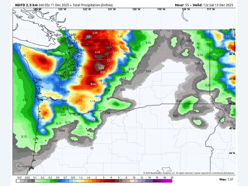
Forecast Models Show Significant New Rainfall Across Western Washington
Latest NDFD precipitation guidance highlights an intense band of heavy rain stretching from the Olympic Peninsula through the Puget Sound region and into north-central Washington. Several areas are projected to exceed 4 inches of new rainfall, with isolated pockets showing potential totals over 5 inches.
The model map indicates widespread red and orange shading across western counties — a clear signal of high-impact rainfall capable of producing rapid rises in rivers and streams. With soils already saturated from earlier storms, additional rain will accelerate runoff, reducing the landscape’s ability to absorb moisture.
Major Flooding Expected on the Skagit and Snohomish Rivers
Hydrologists warn that the Skagit River and Snohomish River are at greatest risk of reaching major or near-record flood stage. Water levels are forecast to rise quickly, threatening homes, roadways, and agricultural areas. Emergency officials caution that flooding may become severe enough to trigger widespread roadway closures, isolate communities, and create hazardous travel conditions.
Low-lying neighborhoods, especially those near levees or floodplains, face the possibility of rapid inundation if rainfall rates exceed forecast values. Residents have been urged to review evacuation plans and stay alert to emergency alerts over the next 24 hours.
Why the Flood Risk Is Increasing So Quickly
This event is driven by a persistent moisture plume entering western Washington, delivering a continuous feed of heavy rainfall. With the region already saturated from repeated storm systems, any additional rain results in faster and more dramatic river responses. The combination of ongoing heavy precipitation and elevated river flows creates a scenario where flooding becomes more likely and more dangerous.
Forecast confidence remains high, as multiple weather models show consistent rainfall amounts and timing. Emergency managers are preparing for potential large-scale evacuations if water levels continue to rise as projected.
What Residents Should Monitor in the Coming Hours
Officials recommend monitoring real-time river gauges, flood warnings, and local emergency notifications. Residents living near major rivers or in known flood zones should be prepared for rapid changes in conditions and follow evacuation instructions immediately if issued.
For continued updates on developing weather hazards and regional emergency alerts, visit NapervilleLocal.com for ongoing coverage.

I’ve lived in Naperville long enough to see how quickly our community changes — from new developments downtown to sudden shifts in our Midwest weather. Reporting on Naperville news and daily forecasts gives me the chance to keep neighbors informed about what really matters. My goal is simple: deliver clear, timely updates so you always know what’s happening in our city and what to expect from the skies above.