
Massive Atmospheric River to Bring More Than 110 Inches of Snow to Mount Rainier’s Upper Elevations While Flash Flood Watches Remain in Effect for Western Washington
Washington — A powerful atmospheric river is forecast to deliver over 110 inches of snow to the upper elevations of Mount Rainier by Friday, with snowfall totals expected to exceed 13,000 feet in elevation across the summit region. Lower elevations of western Washington remain under Flash Flood Watches, as significant rain is projected to accompany the storm system. This event represents one of the strongest moisture surges of the season, bringing simultaneous risks of extreme mountain snowfall and dangerous low-level flooding.
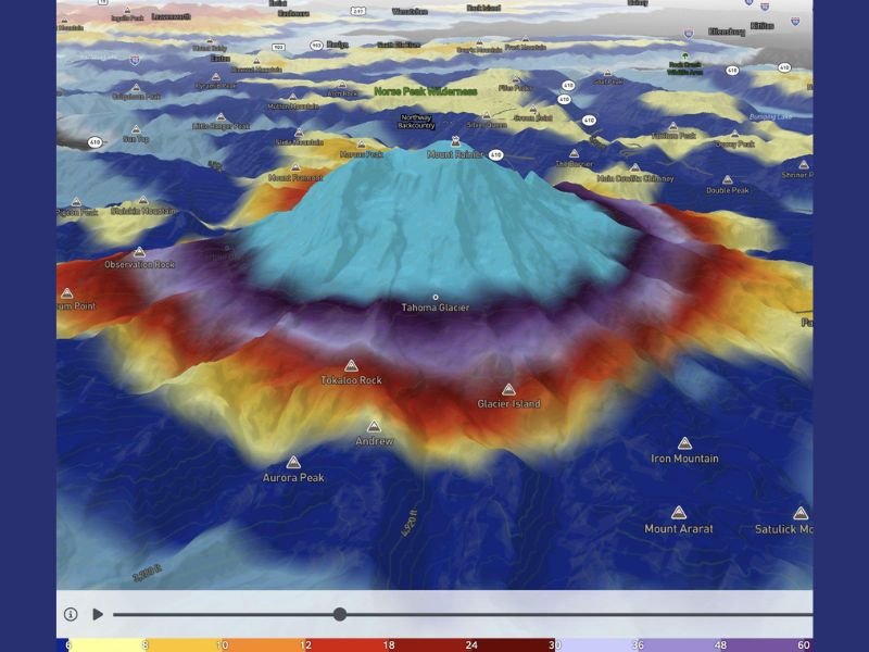
Forecast Models Show Intense Snowfall Concentrated on Mount Rainier’s Summit
High-resolution forecast data shows a concentrated band of extreme snowfall surrounding the summit of Mount Rainier, with projected totals surpassing 110 inches in the highest terrain. The model illustration highlights deep red and purple shading around the volcano’s upper slopes — an indication of exceptionally heavy snow accumulation driven by a sustained plume of Pacific moisture.
Snowfall at this magnitude is typically associated with long-duration atmospheric river events, where warm, moisture-rich air from the Pacific collides with cold upper-elevation air. The result is prolonged, high-intensity snowfall across Mount Rainier’s glaciers, including the Tahoma Glacier, Emmons Glacier, and Ingraham Glacier.
Lower Elevations Face Heavy Rain and Flash Flood Concerns
While the summit and surrounding peaks receive deep snow, communities in the Cascade foothills and western Washington lowlands are expected to see heavy rainfall rather than snow. Flash Flood Watches have been issued due to the risk of rapid runoff, swollen rivers, and saturated soils.
This combination of mountain snow and low-elevation rain raises concerns for hydrologists, as melting snow at mid-elevations or warm rain could accelerate water flow into nearby rivers. Areas near the Nisqually, Puyallup, and White Rivers will need to monitor conditions closely.
Atmospheric River Setup Driving the Extreme Accumulation
The ongoing storm system is fueled by a robust atmospheric river extending from the central Pacific toward the Pacific Northwest. This pattern directs a continuous feed of moisture into Washington State, enhancing precipitation rates at all elevations. The steep elevation profile of Mount Rainier amplifies snowfall, with the strongest accumulation occurring well above the tree line.
Meteorologists note that atmospheric rivers of this strength can produce rapid, significant changes in mountain snowpack, increasing avalanche danger and straining backcountry conditions.
What Residents Should Watch in the Coming Days
Officials recommend that travelers avoid high-elevation routes near Mount Rainier due to the risk of whiteout conditions, road closures, and avalanches. Residents in lower elevations should remain alert to updated flood advisories, rainfall totals, and river gauge readings.
For continued updates on major weather events and emergency alerts across the region, visit NapervilleLocal.com for ongoing coverage.

I’ve lived in Naperville long enough to see how quickly our community changes — from new developments downtown to sudden shifts in our Midwest weather. Reporting on Naperville news and daily forecasts gives me the chance to keep neighbors informed about what really matters. My goal is simple: deliver clear, timely updates so you always know what’s happening in our city and what to expect from the skies above.