
Sharp Dangerous Cold Surge to Hit Illinois, the Midwest, the Ohio Valley, and the Great Lakes With Temperatures 20–40 Degrees Below Normal by Monday
Illinois — A powerful and widespread dangerous cold surge is expected to push into Illinois, the Midwest, the Ohio Valley, and the Great Lakes, bringing temperatures 20 to 40 degrees below normal by Sunday night into Monday. Forecast models show single-digit lows, subzero wind chills, and daytime highs barely above freezing, marking one of the most significant early-season cold outbreaks of the year.
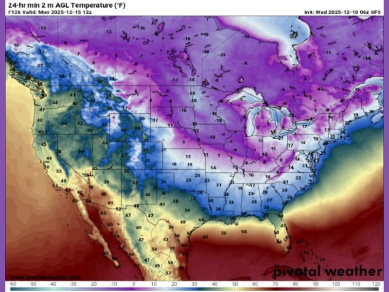
Models Show Extreme Temperature Drops Across Multiple Regions
The latest GFS temperature map displays an expansive area of dark blue and deep purple shading, indicating intense cold air dropping well below seasonal averages. Northern Illinois, Wisconsin, Minnesota, Iowa, Indiana, and Michigan appear positioned within the core of the coldest air.
According to the projection, many locations in the Midwest may start Monday with temperatures in the single digits, while parts of the Upper Midwest could see values sinking below –10°F, especially during the early morning hours. Even areas farther south, including the Ohio Valley and lower Great Lakes, are expected to feel the surge, with widespread lows in the teens and wind chills that dip below zero.
This sharp temperature drop is notable not only for its intensity but also for how early it is occurring in the winter season.
Subzero Wind Chills Expected to Create Hazardous Conditions
The incoming cold surge will generate dangerously low wind chills, particularly across Illinois, Wisconsin, Minnesota, and Michigan. Wind values may make conditions feel 10 to 25 degrees colder than the actual air temperature. This increases the risk of frostbite, especially during the Monday commute or outdoor work periods.
Daytime temperatures may also struggle to rise, with parts of northern Illinois and Wisconsin seeing afternoon highs barely reaching the single digits or low teens. Even Chicago and surrounding suburbs may experience highs in the mid-teens, significantly below climatological averages for mid-December.
What Is Driving the Sudden Temperature Crash
Meteorologists attribute this event to a strong Arctic air mass dropping southward behind a large-scale upper trough. Once the cold front passes, a deep pool of frigid air spreads across the central and eastern United States. The orientation of the jet stream allows cold air to penetrate far south, impacting not just the Upper Midwest but also the Ohio Valley and the Great Lakes corridor.
Because the cold is arriving on the heels of milder temperatures earlier in the week, the contrast will feel especially abrupt.
What Residents Should Prepare For
Residents are encouraged to take precautions against the cold, including limiting time outdoors, preparing homes for extended low temperatures, and ensuring vehicles are winter-ready. Vulnerable populations—particularly seniors, young children, and those without reliable heating—should take extra care.
For continued updates on winter conditions affecting Illinois and surrounding regions, visit NapervilleLocal.com for the latest reporting.

I’ve lived in Naperville long enough to see how quickly our community changes — from new developments downtown to sudden shifts in our Midwest weather. Reporting on Naperville news and daily forecasts gives me the chance to keep neighbors informed about what really matters. My goal is simple: deliver clear, timely updates so you always know what’s happening in our city and what to expect from the skies above.