
Georgia, North Carolina, and South Carolina Set for Dangerous Single-Digit Wind Chills Sunday Night, Forecast Shows
GEORGIA — A surge of Arctic air will bring dangerously low wind chills across Georgia, North Carolina, and South Carolina on Sunday night, with temperatures dropping into the teens and wind chills falling into the single digits and low teens, creating hazardous conditions for residents, pets, and exposed infrastructure.
Major Drop in Temperatures Expected Sunday Evening
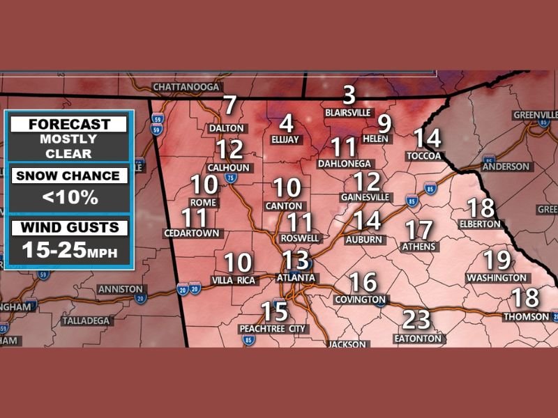
Forecasters warn that low temperatures in the teens combined with 15–25 mph wind gusts will produce wind chills ranging from 3°F to 15°F across North Georgia, with even colder values in parts of western North Carolina. These numbers mark some of the most intense early-season cold readings the region has experienced so far this winter.
Cities across North Georgia are projected to feel severe cold:
- Dalton: 7°F wind chill
- Ellijay: 4°F wind chill
- Blairsville: 3°F wind chill
- Helen: 9°F wind chill
- Gainesville: 12°F wind chill
- Atlanta: 13°F wind chill
- Athens: 17°F wind chill
- Peachtree City: 15°F wind chill
Forecasters emphasize that any exposed skin will feel the impact quickly, especially during late evening and early overnight hours.
Pets, Pipes, and People at Risk During Overnight Hours
With temperatures falling sharply after sunset, residents are urged to take immediate precautions. Bring all pets inside, as the cold will be too dangerous for animals left outdoors. Pipes along exterior walls may freeze, especially in older or poorly insulated homes. Officials recommend dripping faucets and opening cabinets under sinks along outside walls to allow warmer indoor air to circulate.
Wind chills in the single digits also present risks for the elderly, young children, and anyone without adequate shelter. Families are encouraged to check on neighbors and relatives to ensure heat sources are working properly and safely.
Carbon Monoxide Warning as Cold Drives Indoor Heating
Officials warn against using any improper heating sources inside the home. Devices such as grills, generators, or unvented heaters can create deadly carbon monoxide buildup. Residents should rely only on approved heating systems and ensure detectors are functioning.
Low Snow Chances but High Concern for Dangerous Cold
While snow is not expected — forecasters list snow chance under 10% — the combination of clear skies, calm conditions aloft, and strong surface winds will keep temperatures uncomfortably low throughout the night. The coldest conditions will occur between midnight and early Monday morning, when wind chills bottom out across the region.
Cold Sticks Around Into Monday Morning
Monday will remain chilly, with highs struggling through the 30s and lower 40s in many areas. The dangerous cold will gradually ease, but forecasters note that additional cold fronts may arrive later in the week.
Stay with NapervilleLocal.com for continuing updates on severe weather across the U.S.

I’ve lived in Naperville long enough to see how quickly our community changes — from new developments downtown to sudden shifts in our Midwest weather. Reporting on Naperville news and daily forecasts gives me the chance to keep neighbors informed about what really matters. My goal is simple: deliver clear, timely updates so you always know what’s happening in our city and what to expect from the skies above.