
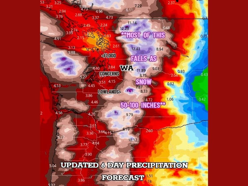
Washington Braces for Major Mountain Snow as Up to 100 Inches of Precipitation Expected This Week
WASHINGTON — A powerful snow-and-rain event is set to impact the state, with elevations above 3,000 feet expected to receive mostly snow and totals reaching 4 to 8 feet by the weekend. Updated precipitation outlooks show an exceptionally wet period from Thursday through Saturday morning, with widespread impacts possible across both the mountains and lowlands.
Heavy Snow for the Cascades and Higher Terrain
Forecast models indicate that most of the highest precipitation totals—some reaching 50 to 100 inches—will fall as snow in the mountains, significantly reducing the flood risk. Areas above 3,000 feet in the Cascades and Olympics are expected to see persistent heavy snowfall, creating hazardous travel conditions through the end of the week.
Lowland Flood Concerns Remain
While the bulk of the extreme totals should remain in snowy elevations, lowland regions of western Washington may still face flooding risks. Some locations could see 3 to 6 inches of rain, which may overwhelm rivers, streams, and drainage systems in the most vulnerable communities.
Travel Impacts Likely
The combination of heavy mountain snow and steady lowland rain is expected to create significant travel challenges across the region. Mountain passes will likely experience dangerous snow-covered roads, reduced visibility, and chain requirements. Residents planning to commute or travel over higher terrain on Friday or Saturday are urged to monitor updated pass reports.
Why Flooding Risk Is Lower Than Expected
Despite the large precipitation totals shown on forecast maps, meteorologists note that the highest values are occurring where temperatures are cold enough for snow, not rain. This will help limit widespread flooding, though localized flood issues remain possible, especially in low-lying communities.
Preparing for the End-of-Week Storm
Officials advise residents to take precautions ahead of the approaching system, including:
- Allow extra travel time, especially through the mountains
- Stay updated on changing pass conditions and closures
- Prepare for power outages in areas expecting heavy wet snow
- Secure outdoor items in regions expecting strong winds
This storm system will continue to evolve, and updated forecasts will be issued as new data becomes available. For more local weather updates and breaking alerts, stay connected with NapervilleLocal.com.

I’ve lived in Naperville long enough to see how quickly our community changes — from new developments downtown to sudden shifts in our Midwest weather. Reporting on Naperville news and daily forecasts gives me the chance to keep neighbors informed about what really matters. My goal is simple: deliver clear, timely updates so you always know what’s happening in our city and what to expect from the skies above.