
Massive Storm Pattern to Bring Heavy Rain and Mountain Snow to California and the Western U.S. Later This Week
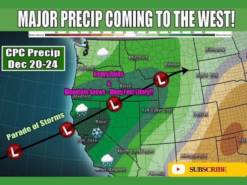
CALIFORNIA — A powerful and extremely wet pattern is expected to develop across the western United States by the end of the week, with multiple storms lined up to deliver heavy precipitation, significant mountain snowfall, and the potential for widespread flooding in lower-elevation regions. Forecast maps show an aggressive parade of Pacific systems pushing toward the West Coast between December 20–24, signaling one of the most active stretches of the month.
Multiple Storms Set to Deliver Heavy Rainfall
Meteorologists warn that several waves of moisture will move inland, bringing heavy rains to California, Oregon, Washington, Idaho, and Nevada. Some areas may see repeated rounds of downpours, increasing the risk of flash flooding, urban flooding, and rising river levels.
The CPC precipitation outlook highlights a strong above-normal rainfall signal across nearly the entire western region. Coastal and valley areas should expect prolonged rain events, reduced visibility, and challenging travel conditions.
Mountain Snowfall Could Measure in Feet
High-elevation regions—including the Sierra Nevada, Cascades, and parts of the Northern Rockies—are forecast to receive many feet of snow, with some peaks potentially seeing 10 feet or more through the weekend.
This level of snowfall would significantly improve snowpack but also increase avalanche danger and create hazardous mountain travel.
“Parade of Storms” Taking Aim at the West
Forecast visuals show a persistent train of low-pressure systems sweeping from the Pacific into California before pushing inland toward the Intermountain West. Each storm will reinforce the next, producing a continuous period of heavy precipitation and strong onshore flow.
This setup resembles past atmospheric river patterns, though the provided data does not explicitly label this event as one.
Flooding Risks Growing for Warmer Regions
Lower-elevation areas not cold enough for snow may face widespread heavy rain.
Forecasters emphasize the potential for:
- Rapid runoff from steep terrain
- Urban flooding in major metro zones
- Rising creek and river levels
- Landslide risks in saturated soil regions
Residents in flood-prone locations should remain alert as rainfall accumulates.
What Residents Should Prepare For
- Heavy rain lasting multiple days
- Snowfall totals measured in feet in higher elevations
- Difficult mountain pass travel
- Flooding concerns across warmer areas
- Reduced visibility and slow commutes
Conditions are expected to worsen late in the week and persist into early next week. For continuing weather updates and regional forecast developments, stay with NapervilleLocal.com.

I’ve lived in Naperville long enough to see how quickly our community changes — from new developments downtown to sudden shifts in our Midwest weather. Reporting on Naperville news and daily forecasts gives me the chance to keep neighbors informed about what really matters. My goal is simple: deliver clear, timely updates so you always know what’s happening in our city and what to expect from the skies above.