
Washington State Braces for 1–3 Feet of Mountain Snow and Near-Blizzard Conditions From Tuesday Night to Thursday
WASHINGTON — A significant winter storm is set to impact the Washington Cascades and Olympic Mountains beginning late Tuesday and lasting through early Thursday, bringing 1 to 3 feet of heavy mountain snow, rapidly falling snow levels, and the potential for near-blizzard conditions across higher elevations and travel passes.
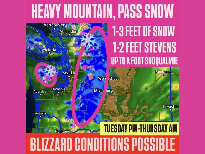
Heavy Snow Expected Across the Cascades and Olympics
Forecasters report that the storm will drop 1–3 feet of snow in the mountains, with the highest peaks receiving the most accumulation. Stevens Pass may see 1–2 feet, while Snoqualmie Pass could receive up to a foot.
Snow levels are expected to fall to around 2,000 feet, meaning a wider range of terrain will experience accumulating snowfall.
Difficult Travel and Low Visibility Likely
Officials warn that the combination of heavy snowfall and strong winds may significantly reduce visibility, creating near-blizzard conditions in the passes and higher elevations. Drivers are urged to check pass reports, traction-tire requirements, and chain laws before traveling.
Impact on Ski Areas and Outdoor Recreation
While travel conditions will be hazardous, the storm brings much-needed snow to ski areas across Washington that have been awaiting deeper coverage for seasonal operations. Resorts in the Cascades stand to benefit substantially from the incoming storm totals.
Timing of the Storm
The heaviest snow is expected from Tuesday night through Wednesday, tapering off by early Thursday morning as the storm moves east.
For more winter weather updates and breaking local coverage, visit NapervilleLocal.com.

I’ve lived in Naperville long enough to see how quickly our community changes — from new developments downtown to sudden shifts in our Midwest weather. Reporting on Naperville news and daily forecasts gives me the chance to keep neighbors informed about what really matters. My goal is simple: deliver clear, timely updates so you always know what’s happening in our city and what to expect from the skies above.