
Missouri Issues Urgent Tornado Warning as Severe Storm Near Troy and Elsberry Tracks East at 35 MPH
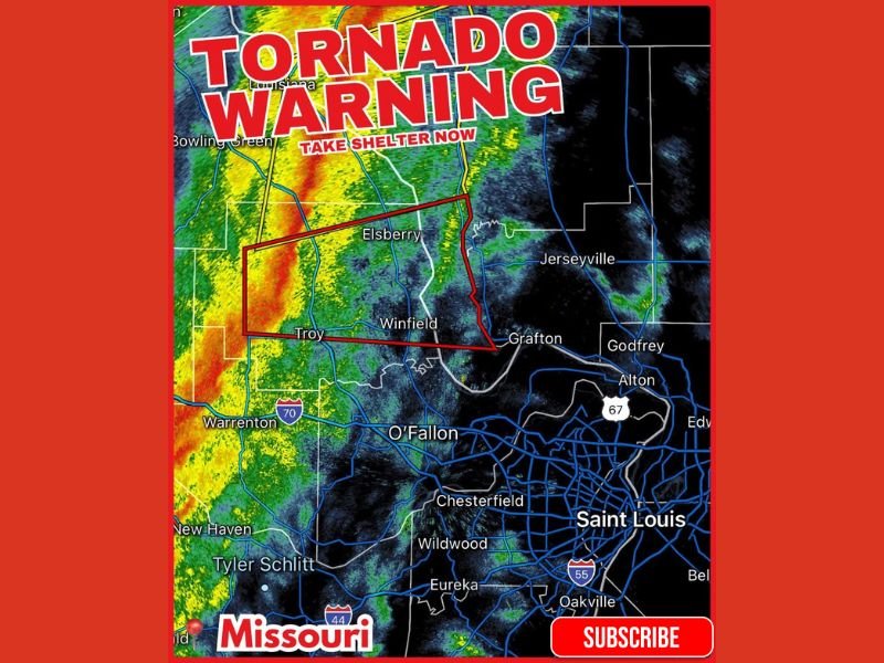
MISSOURI — Communities northwest of St. Louis were placed under an urgent tornado warning after a severe thunderstorm capable of producing a tornado developed near Davis, Missouri, tracking east at 35 miles per hour. Radar imagery shared by LiveStormChasers shows the warning polygon stretching across Troy, Elsberry, Winfield, and surrounding areas, prompting immediate alerts for residents to seek shelter.
The storm, part of a broader line of intense weather sweeping across eastern Missouri, exhibited strong rotation as it moved into Lincoln County. Meteorologists emphasized that even without a confirmed tornado on the ground, conditions were favorable for rapid tornado development.
What Areas Were Most at Risk
The tornado warning zone included several rural and suburban communities northwest of St. Louis, particularly:
- Troy
- Elsberry
- Winfield
- Areas near Grafton and Jerseyville, just across the Illinois border
Radar scans revealed a well-organized storm structure with heavy rainfall, strong winds, and embedded rotation. The warning urged residents to take shelter immediately, avoid windows, and move to interior rooms or basements until the storm passed.
Local emergency managers emphasized the importance of treating all tornado warnings seriously, noting that nighttime or fast-moving storms reduce visibility and increase danger.
Impact on Regional Travel and Weather Conditions
Heavy rain and deteriorating visibility created hazardous travel conditions along stretches of Interstate 70 near Warrenton and Highway 61 moving toward the Troy area. Strong winds associated with the storm were likely to cause scattered power outages, fallen branches, and potential debris on roadways.
Communities closer to the St. Louis metro area, including O’Fallon, Chesterfield, and Alton, were advised to remain alert as the line of storms continued moving east. Although these areas were not initially within the tornado warning polygon, the National Weather Service cautioned that additional warnings could be issued if rotation strengthened.
Why This Matters for Readers in Illinois and Naperville
While this warning was centered in Missouri, severe storm systems of this type often progress into Illinois, affecting communities from Alton to the Chicago region depending on atmospheric patterns. Residents in Naperville are reminded that winter and early-spring setups can still produce dangerous tornado-capable storms, and preparedness remains essential year-round.
For continued updates on severe weather, safety alerts, and Midwest storm tracking, stay connected with NapervilleLocal.com.

I’ve lived in Naperville long enough to see how quickly our community changes — from new developments downtown to sudden shifts in our Midwest weather. Reporting on Naperville news and daily forecasts gives me the chance to keep neighbors informed about what really matters. My goal is simple: deliver clear, timely updates so you always know what’s happening in our city and what to expect from the skies above.