
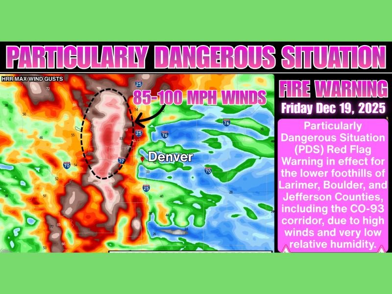
Colorado Under Particularly Dangerous Fire Weather Warning as 85–100 MPH Wind Gusts Threaten Boulder and Jefferson Counties
COLORADO — State officials issued an urgent Particularly Dangerous Situation (PDS) fire weather warning for Friday as powerful winds, extremely dry air, and high wildfire risk converge across the foothills of Boulder and Jefferson Counties, especially between 5,500 and 9,000 feet. The warning highlights the potential for rapidly spreading fires due to wind gusts that could reach 85–100 miles per hour.
The extreme conditions are expected to develop from early Friday morning into the evening, prompting meteorologists and emergency managers to urge residents to avoid any activity that could accidentally spark a fire. With humidity levels forecast to drop into the low teens or even single digits, even a small ignition source could escalate quickly.
Critical Weather Conditions Expected
Forecasters warn that strong west winds will sustain 45–55 mph, with localized gusts possibly exceeding 100 mph along the Front Range foothills. The combination of intense winds and dry air will create a highly volatile environment.
According to fire weather specialists, these conditions represent some of the most hazardous non-thunderstorm wind scenarios Colorado experiences. Any new fire could spread extremely rapidly, especially in cured grasses and open terrain.
The most dangerous areas include:
- Highway 93 corridor from Jefferson County into Boulder County
- US-36 north of Boulder toward the Larimer County line
- Westward foothill communities above 5,500 feet
Areas near and east of I-25 may see lighter winds, but gusts of 25–40 mph combined with very low humidity can still produce critical fire weather.
Impact on Residents and Safety Precautions
Emergency officials urge residents to secure outdoor objects, avoid open flames, and stay alert to any smoke or fire sightings. Downed power lines are also a concern with wind gusts surpassing hurricane force in exposed foothill locations.
Communities near Boulder, Golden, and Superior—areas historically affected by destructive wildfires—have been advised to remain prepared for rapidly changing conditions. Authorities stress that the PDS designation is rare and indicates exceptionally dangerous fire potential.
Why This Matters for Readers in Illinois
High wind-driven wildfire events in western states can affect air quality patterns across the Midwest, including Illinois. Significant smoke transport is possible when large fires develop under extreme wind conditions. For ongoing updates on severe weather risks and regional environmental impacts, continue following NapervilleLocal.com.

I’ve lived in Naperville long enough to see how quickly our community changes — from new developments downtown to sudden shifts in our Midwest weather. Reporting on Naperville news and daily forecasts gives me the chance to keep neighbors informed about what really matters. My goal is simple: deliver clear, timely updates so you always know what’s happening in our city and what to expect from the skies above.