
Alabama Communities Under Tornado Warning as Dangerous Storm Approaches Scottsboro, Henagar, and Hollywood
ALABAMA — A fast-moving storm system prompted an urgent tornado warning for Scottsboro, Henagar, and Hollywood as radar detected strong rotation capable of producing a tornado late Monday evening. The warning remains in effect until 9:15 PM CST, with meteorologists urging residents in northeastern Alabama to take immediate shelter.
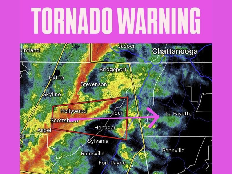
Radar imagery shows a pronounced line of intense thunderstorms stretching from Aspel and Skyline through Hollywood, Scottsboro, and Henagar, pushing east toward the Georgia state line. Within this line, a rotating storm segment has triggered warning polygons spanning portions of Jackson and DeKalb Counties.
Storm Showing Strong Rotation on Radar
Meteorologists identified a well-defined rotating feature embedded within a broader squall line, raising concern for a potential rain-wrapped tornado. These types of tornadoes are particularly dangerous because heavy precipitation can obscure visibility, giving residents little time to react without alert systems.
The warning zone covers:
- Scottsboro
- Hollywood
- Henagar
- Surrounding rural areas including Ider, Sylvania, and northern DeKalb County
A bright red corridor on radar indicates intense wind and heavy rainfall, with movement directed toward LaFayette and northwestern Georgia.
Communities Urged to Take Shelter Immediately
Emergency officials urge residents to move to interior rooms, basements, or storm shelters, avoiding windows and exterior walls. Mobile homes and vehicles are considered unsafe during tornado-warned storms, especially when rotation is already detected.
Schools, businesses, and first responders across the region have been placed on heightened alert. The storm’s rapid forward speed increases risk, as severe thunderstorms in Alabama often intensify quickly along the foothills.
Why This Matters for Illinois Readers
Though this event is centered in Alabama, severe storm outbreaks in the Deep South often influence larger weather patterns extending into the Midwest. Systems capable of generating tornadoes can eventually lift northeast toward states like Illinois, bringing strong winds, heavy rain, or colder air depending on seasonal dynamics.
Tracking national severe weather helps Naperville residents stay prepared when similar atmospheric conditions form closer to home.
For continued updates on tornado warnings, Midwest weather impacts, and national severe storm alerts, stay connected with NapervilleLocal.com.

I’ve lived in Naperville long enough to see how quickly our community changes — from new developments downtown to sudden shifts in our Midwest weather. Reporting on Naperville news and daily forecasts gives me the chance to keep neighbors informed about what really matters. My goal is simple: deliver clear, timely updates so you always know what’s happening in our city and what to expect from the skies above.