
Pacific Northwest Faces Flash Flood Risk as Atmospheric River Brings Heavy Rain to Oregon and Washington
OREGON — Communities across western Oregon and parts of Washington are under an elevated flash flood risk tonight as an intense atmospheric river continues to drive heavy rainfall into the region. Forecasters warn that additional rounds of moisture could bring one to two more inches of rain, increasing the likelihood of flooding in rivers, creeks, and low-lying urban areas.
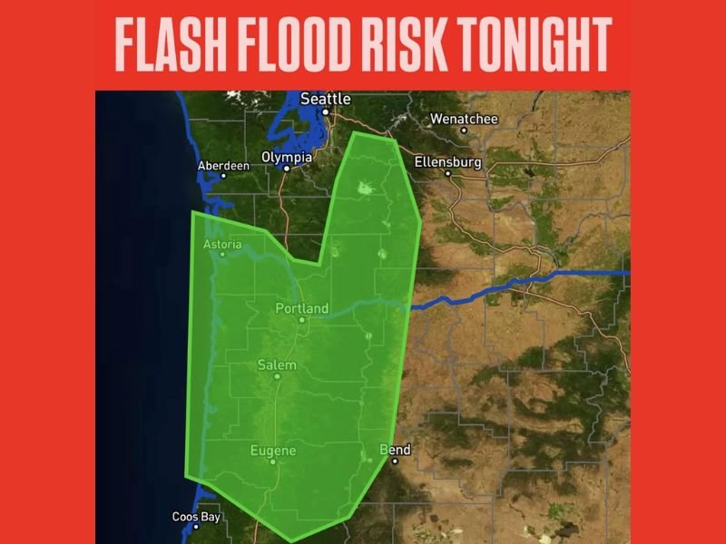
The latest guidance shows a broad flood-risk zone stretching from Astoria and the Oregon Coast through Portland, Salem, and Eugene, extending eastward toward the Cascades. Foothill areas in Washington may also experience significant runoff as saturated terrain struggles to absorb additional rainfall.
Atmospheric River Bringing Prolonged Rainfall
Atmospheric rivers — long, narrow channels of concentrated tropical moisture — often produce prolonged periods of heavy rain along the West Coast. Tonight’s system continues a multi-day event that has already drenched portions of Oregon.
Forecasters note that the Cascades and western foothills could see particularly intense rainfall, increasing the risk of rapid rises in streams and creeks. Poor-drainage zones within larger metro areas, including parts of Portland, may also experience urban flooding. Residents are urged to remain alert, avoid areas prone to flooding, and never drive into high water, even if it appears shallow.
Areas at Most Risk Tonight
The most significant flash flood concerns include:
- Portland metro area, where urban drainage systems may be overwhelmed
- Salem and the central Willamette Valley, with widespread moderate-to-heavy rain
- Eugene and southern valley communities, where saturated soils increase runoff
- Coastal areas near Astoria and Coos Bay, exposed to continuous moisture inflow
- Western Washington foothills, where upslope flow enhances rainfall totals
Rivers and creeks are expected to continue rising through the night, with potential flooding in areas already near capacity.
Why This Matters for Illinois Readers
Atmospheric river events in the Pacific Northwest often influence broader U.S. weather patterns. Heavy West Coast precipitation can strengthen downstream storm systems that later impact the Midwest, including Illinois. Such events occasionally shift jet stream patterns, altering temperature trends and precipitation chances for the Chicago region.
For ongoing coverage of national weather threats and their potential Midwest impacts, stay connected with NapervilleLocal.com.

I’ve lived in Naperville long enough to see how quickly our community changes — from new developments downtown to sudden shifts in our Midwest weather. Reporting on Naperville news and daily forecasts gives me the chance to keep neighbors informed about what really matters. My goal is simple: deliver clear, timely updates so you always know what’s happening in our city and what to expect from the skies above.