
West Coast Faces 7–10 Days of Back-to-Back Storms With Heavy Rain, Flooding Risks, and 60 MPH Winds From Washington to California
WESTERN UNITED STATES — A powerful and prolonged storm pattern is set to impact the West Coast over the next 7–10 days, delivering repeated rounds of heavy downpours, damaging winds, and widespread flooding risk from Washington to California. More than 500,000 customers are already without power in parts of the Pacific Northwest as flood watches and wind alerts remain in effect.
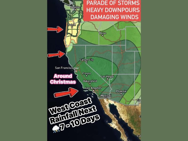
Meteorologists warn that the storm train — often referred to as a parade of storms — will continue to bring significant rainfall totals, especially across western Washington and Oregon, before shifting into Northern and Southern California as Christmas approaches.
Pacific Northwest Hit First With Heavy Rain and Strong Winds
Flood watches are in place from Seattle to Portland, with the heaviest rainfall concentrated in the corridor from Salem to Eugene. Multi-inch totals are expected, along with wind gusts of 40 to 60 mph — and in some exposed coastal areas, gusts may briefly reach hurricane force.
The saturated ground, combined with ongoing winds, increases the risk of:
- Downed trees
- Power outages
- Urban and river flooding
- Landslides in steep terrain
Officials emphasize that the Pacific Northwest will remain under persistent moisture plumes for several consecutive days.
Storm System Moves Into California This Weekend
As the storm pipeline shifts south, Northern California will see the next surge of heavy rainfall, raising flash flood concerns from Eureka through Sacramento. Dark green shading on forecast maps shows the zones likely to receive multi-inch rainfall totals.
By midweek leading into Christmas, the heaviest rain will expand into:
- Santa Barbara
- Bakersfield
- Los Angeles
- San Diego
Interior areas, including Las Vegas, will also begin to trend wetter as moisture spreads inland.
Why This Pattern Matters Nationally and for Illinois
Extended storm cycles along the West Coast often play a key role in shaping downstream weather patterns across the U.S. Increased Pacific moisture and upper-level energy can influence late-December systems that eventually reach the Midwest, potentially affecting Illinois travelers and holiday plans.
For continued updates on national storm patterns and Midwest weather impacts, follow NapervilleLocal.com for comprehensive, reliable coverage.

I’ve lived in Naperville long enough to see how quickly our community changes — from new developments downtown to sudden shifts in our Midwest weather. Reporting on Naperville news and daily forecasts gives me the chance to keep neighbors informed about what really matters. My goal is simple: deliver clear, timely updates so you always know what’s happening in our city and what to expect from the skies above.