
Multiple Atmospheric Rivers Set to Drench the West Coast Through Year’s End With Heavy Rain, Flooding Risks, and Feet of Mountain Snow
WESTERN UNITED STATES — A powerful and persistent wet-weather pattern is expected to dominate the West Coast through the end of the year as multiple atmospheric rivers line up across the Pacific. Meteorologists warn that the extended series of storms will bring inches of rain to coastal regions, moisture into the desert Southwest, and several feet of snow to the highest elevations of the Sierra Nevada, Cascades, and Olympic Mountains.
The pattern includes a prolonged atmospheric river forecast to arrive during Christmas week, heightening flooding concerns and increasing the risk of landslides and debris flows, particularly in areas scarred by recent wildfires.
Widespread Rainfall Expected Across Western States
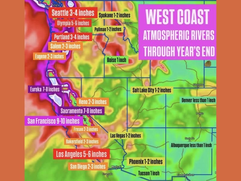
Forecast models show substantial rainfall totals from Washington to Southern California, including:
- Seattle: 3–4 inches
- Olympia: 5–6 inches
- Portland: 3–4 inches
- Eugene and Salem: 2–3 inches
- Eureka: 7–8 inches
- Sacramento: 7–8 inches
- San Francisco: 9–10 inches
- Los Angeles: 5–6 inches
- San Diego: 2–3 inches
Inland cities will also receive noticeable rainfall, including Boise, Salt Lake City, Las Vegas, Phoenix, Tucson, and portions of Idaho and Montana, though amounts will be lower than coastal regions.
Flooding, Landslides, and Debris Flows Remain Major Concerns
Because many areas have already experienced significant rainfall in recent weeks, the ground remains saturated. Flooding risks will rise sharply where rainfall totals reach multiple inches within short time periods.
Emergency officials warn that debris flows and landslides may be triggered in mountainous or recently burned terrain. These hazards are particularly dangerous because they can occur suddenly and with little warning. Low-lying urban areas may also face street flooding, overwhelmed storm drains, and travel disruptions as the storms progress.
Heavy Mountain Snowfall Will Build High-Elevation Snowpack
Higher elevations of the Sierra, Cascades, and Olympics are projected to receive numerous feet of snow. Early estimates suggest 4–5+ feet in some areas by the end of next week, improving snowpack conditions that have been below average.
However, the heavy snowfall will also pose dangerous mountain travel conditions, with chain requirements or pass closures likely during peak storm periods.
Why This Matters for Midwest Readers
Large-scale storm patterns along the West Coast often influence national weather dynamics. The energy and moisture associated with these atmospheric rivers can help fuel storm systems that eventually move into the Midwest, affecting Illinois travel and holiday plans. For continued national weather coverage and how evolving patterns may impact the Chicago region, stay with NapervilleLocal.com.

I’ve lived in Naperville long enough to see how quickly our community changes — from new developments downtown to sudden shifts in our Midwest weather. Reporting on Naperville news and daily forecasts gives me the chance to keep neighbors informed about what really matters. My goal is simple: deliver clear, timely updates so you always know what’s happening in our city and what to expect from the skies above.