
Colorado and Wyoming Placed Under First-Ever PDS Red Flag Warning as 100+ mph Winds Create Life-Threatening, Explosive Fire Risk Across the Front Range
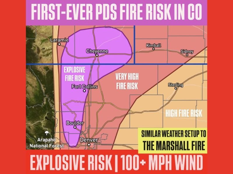
COLORADO & WYOMING — A historic and life-threatening fire danger is unfolding today across the Colorado Front Range and southeastern Wyoming as officials issue the first-ever Particularly Dangerous Situation (PDS) Red Flag Warning for the region. Meteorologists warn that wind gusts between 85 and 105 mph, combined with extremely low humidity and dry grasses, could lead to explosive fire growth capable of spreading faster than residents can react.
Officials urge residents in these high-risk zones to be prepared for immediate evacuation, assemble go-bags, and keep pets and loved ones ready to relocate at a moment’s notice.
Wind Speeds Rivaling the Marshall Fire Setup
The National Weather Service warns that today’s atmospheric setup closely resembles conditions seen during the 2021 Marshall Fire, one of Colorado’s most destructive wildfires. Winds are expected to blast down the foothills and across cities including:
- Boulder
- Fort Collins
- Denver metro area
- Cheyenne, Wyoming
These winds, combined with bone-dry vegetation, could turn even a small spark into a rapidly advancing fire front.
Explosive Fire Risk Across the Front Range
According to fire risk mapping:
- A purple zone from Boulder to Cheyenne is under EXPLOSIVE FIRE RISK, meaning fires could become uncontrollable immediately after ignition.
- Surrounding areas, including the I-25 corridor, face very high fire danger stretching into northeastern Colorado.
- Southeastern Wyoming, including Cheyenne and surrounding farmland, remains especially vulnerable due to open terrain and extreme wind exposure.
Officials note that fires in these conditions can outrun firefighters, jump containment lines, and spread unpredictably.
Residents Urged to Stay Alert and Prepare
Authorities emphasize the importance of:
- Knowing evacuation routes
- Keeping phones charged and alerts enabled
- Avoiding any activity that could produce sparks
- Monitoring conditions closely throughout the day
Even simple actions — such as dragging a chain, discarding a cigarette, or operating machinery — could trigger a rapidly spreading wildfire under these historically dangerous conditions.
Why This Matters for Illinois Readers
While today’s threat centers on Colorado and Wyoming, extreme wildfire weather in the West often influences national air quality patterns, travel routes, and long-term climate impacts that eventually reach the Midwest. Illinois residents could see future haze or flight delays depending on the scale of any fires that ignite. For ongoing national weather and hazard updates, continue following NapervilleLocal.com.

I’ve lived in Naperville long enough to see how quickly our community changes — from new developments downtown to sudden shifts in our Midwest weather. Reporting on Naperville news and daily forecasts gives me the chance to keep neighbors informed about what really matters. My goal is simple: deliver clear, timely updates so you always know what’s happening in our city and what to expect from the skies above.