
Colorado Issues First-Ever PDS Red Flag Warning as 90–105 mph Winds Threaten Explosive Fire Conditions in Boulder and Jefferson Counties
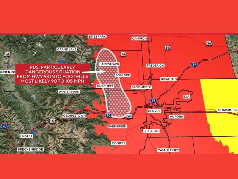
COLORADO — For the first time in state history, the National Weather Service office in Boulder has issued a Particularly Dangerous Situation (PDS) Red Flag Warning for extreme fire danger across northern Jefferson County and western Boulder County. Forecasters warn that wind gusts between 85 and 105 mph could develop Friday between 10 a.m. and midnight, creating an environment where any spark could produce an uncontrollable, fast-moving wildfire.
The warning specifically covers a corridor stretching from Highway 93 into the Colorado foothills, including communities near Pinecliffe, Jamestown, and western Boulder — areas known for steep terrain, dry grasses, and strong downslope wind potential.
Wind Conditions Comparable to Historic Fire Outbreaks
Meteorologists describe the setup as “rare and dangerous,” noting its similarity to atmospheric patterns that have produced destructive fires in the past. Forecast models show intense mountain-wave winds descending into the foothills, capable of:
- Toppling trees
- Downing power lines
- Sending embers long distances
- Producing fire spread rates faster than firefighters can contain
Communities along the western edge of the Denver metro, including Broomfield, Arvada, Evergreen, and parts of Jefferson County, will also be exposed to high wind and elevated fire danger.
Why Officials Issued a PDS-Level Fire Warning
A PDS Red Flag Warning is extremely rare and is reserved only for the most dangerous fire weather setups. It indicates that:
- Conditions are favorable for explosive fire growth
- Fires may become life-threatening within minutes
- Evacuation orders may be issued quickly with little notice
Officials strongly advise residents to keep a go-bag ready, review evacuation routes, secure outdoor items that could blow away, and avoid any activities that could generate sparks.
Travel and Safety Concerns
The wind threat also poses risks unrelated to fire. High-profile vehicles traveling along Highway 93, I-70, and foothill routes may face hazardous crosswinds. Some local roads may close if gusts exceed safe thresholds.
Xcel Energy and statewide emergency managers are preparing for the possibility of preemptive power shutoffs in high-risk fire zones.
Why This Matters for Illinois Readers
Major fire events in the West can affect national air quality, aviation routes, and long-range weather patterns, which may eventually impact Illinois. For continued national weather and hazard updates, visit NapervilleLocal.com.

I’ve lived in Naperville long enough to see how quickly our community changes — from new developments downtown to sudden shifts in our Midwest weather. Reporting on Naperville news and daily forecasts gives me the chance to keep neighbors informed about what really matters. My goal is simple: deliver clear, timely updates so you always know what’s happening in our city and what to expect from the skies above.