
Illinois Braces for Sharp Temperature Crash as Strong Cold Front Arrives Sunday, Dropping 60s to 30s Within Hours
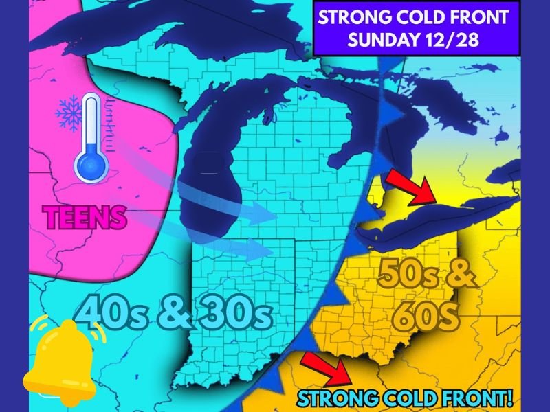
ILLINOIS — A powerful cold front sweeping across the Midwest on Sunday, December 28, is expected to send temperatures in Illinois plunging dramatically, dropping from the 50s and 60s in the morning to the 30s by the afternoon, according to new weather model updates. Meteorologists warn that the abrupt temperature shift will be one of the most significant single-day cooldowns of the month.
A Sharp Temperature Drop Expected
Forecast maps show warm air ahead of the front lingering over Illinois early Sunday, with widespread upper-50s and mid-60s likely during the morning hours. Once the cold front pushes through, temperatures will fall rapidly into the 30s, with even colder air over neighboring states.
Behind the front, much of the Upper Midwest will plunge into the 40s, 30s, and even the teens, especially farther west into the Dakotas and Minnesota. The advancing boundary will cut directly across Illinois, bringing fast-moving colder air and gusty winds. Meteorologists note that it is still too early to determine the full extent of impacts, but confidence is high regarding the rapid cooldown.
Wind Shift and Possible Precipitation
As the cold air rushes in, forecasters expect a sharp wind shift. While widespread snow is not expected Sunday in Illinois, the colder temperatures will create conditions favorable for lake-effect snow on Monday, particularly across northwestern Indiana and areas downwind of Lake Michigan.
At this time, model guidance indicates that snow accumulation potential will remain limited for most of Illinois. However, forecasters advise that overnight temperature drops could create slick spots if any light precipitation develops behind the front.
Why the Front Is So Strong
The significant temperature contrast driving the system is the primary factor behind its strength. Warm air lingering across Indiana, Ohio, and portions of the eastern Midwest will be replaced quickly by much colder Arctic-influenced air from the west.
The collision of these temperature zones is what produces such a dramatic swing, causing temperatures to crash more than 20–30 degrees in a matter of hours.
What Residents Should Expect
Residents across Naperville and the broader region should prepare for:
• A rapid fall in temperatures Sunday afternoon
• Gusty winds accompanying the cold front
• A chilly Sunday night with lows dipping into the 20s
• Possible lake-effect snow impacting travel into NW Indiana Monday
• A much colder start to the week
Forecasters recommend monitoring updated advisories through the weekend, as confidence in timing and potential impacts will continue to improve. Stay with NapervilleLocal.com for ongoing weather updates and local forecasts that help keep you prepared.

I’ve lived in Naperville long enough to see how quickly our community changes — from new developments downtown to sudden shifts in our Midwest weather. Reporting on Naperville news and daily forecasts gives me the chance to keep neighbors informed about what really matters. My goal is simple: deliver clear, timely updates so you always know what’s happening in our city and what to expect from the skies above.