
Los Angeles, California Issues Emergency Evacuation Warning for Pacific Palisades and Mandeville Canyon as Debris Flows and Major Flooding Threaten Burn Scar Areas
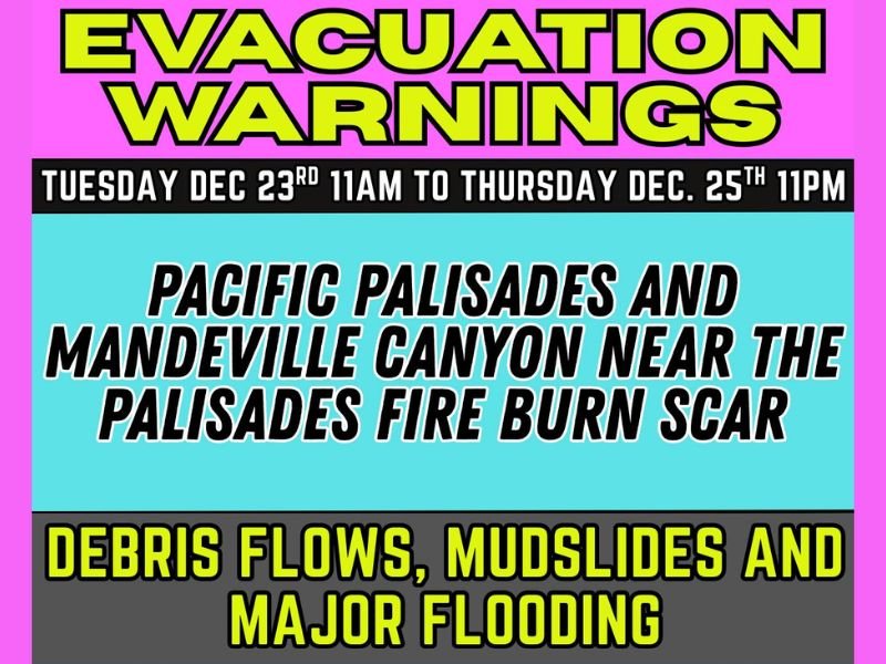
LOS ANGELES, California — City officials have issued an urgent evacuation warning for multiple neighborhoods in the hills above Los Angeles as heavy rainfall increases the threat of debris flows, mudslides, and major flooding near several wildfire burn scars. The warning is in effect from 11 a.m. Tuesday, December 23, through 11 p.m. Thursday, December 25, covering a 60-hour period of heightened danger.
The alert specifically targets communities near the Palisades Fire burn scar, including Pacific Palisades and Mandeville Canyon, where steep terrain and unstable soil drastically increase the likelihood of fast-moving debris slides. Officials also included areas impacted by previous fires, including Eaton, Agua Dulce, Lidia, Franklin, Bridge, Canyon, Owen, Hurst, and Kenneth fires.
Officials Warn of Immediate Risk: Debris Flows Possible at Any Time
According to emergency managers, intense rainfall expected throughout the warning window could rapidly trigger dangerous debris flows, especially where vegetation was destroyed during past wildfire seasons. These flows can occur with little to no warning and are capable of carrying mud, rocks, fallen trees, and structural debris downhill at high speeds.
Authorities emphasize that residents in evacuation zones should be prepared to leave immediately, noting that debris flows are among the most life-threatening hazards following major storms in burn-scarred regions.
Why These Areas Are at High Risk
The neighborhoods under warning sit beneath slopes weakened by wildfire activity. Without vegetation to absorb rainfall or stabilize soil, stormwater can quickly undermine hillsides. Officials warn that the forecasted storm system could bring rainfall rates strong enough to overwhelm drainages and trigger sudden slope failures.
This threat is further heightened because the burn scar areas “respond dramatically” even to moderate rainfall. As a result, the National Weather Service and Los Angeles Emergency Management Department have been closely monitoring the developing conditions.
Residents Urged to Take the Evacuation Warning Seriously
City officials are urging all residents within the affected zones to prepare now. Recommended actions include:
• Packing essential documents, medication, and emergency supplies
• Avoiding canyon roads prone to washouts and closures
• Keeping phones charged and alerts enabled for emergency notifications
• Staying off roadways during peak rainfall due to flash-flood risk
Authorities also remind residents that if evacuation orders replace the current warning, they will be issued with little advance notice. “If you feel unsafe at any time, leave early,” officials said.
Storm System Expected to Intensify Over Two Days
The strongest rainfall is projected to occur between Tuesday night and Thursday, with additional periods of heavy downpours possible. Forecasters warn that storm dynamics could shift quickly, potentially increasing the risk window further. Residents across the Los Angeles hillsides are urged to follow official updates closely as conditions evolve.

I’ve lived in Naperville long enough to see how quickly our community changes — from new developments downtown to sudden shifts in our Midwest weather. Reporting on Naperville news and daily forecasts gives me the chance to keep neighbors informed about what really matters. My goal is simple: deliver clear, timely updates so you always know what’s happening in our city and what to expect from the skies above.