
Snowfall Forecast Drops as Warmer System Moves Into New England, Reducing Expected Totals in Massachusetts, Connecticut, and Rhode Island
NEW ENGLAND — A developing winter system running ahead of schedule and warmer than initially projected is now expected to significantly reduce snowfall totals across southern New England, forecasters said late Monday. The shift in temperature is altering the storm dynamics and limiting the amount of accumulation that had been previously expected for areas including Massachusetts, Connecticut, and Rhode Island.
Meteorologists tracking the storm note that the system’s warmer temperature profile is pushing the snow–rain line farther north, preventing widespread accumulation in southern parts of the region. While snowfall had already been forecast to be modest, updated radar and atmospheric data now show even lower totals are likely.
Warmer Air Cutting Into Expected Snowfall
Early projections indicated that parts of southern New England could receive a light blanket of snow as the system moved up the East Coast. However, the storm is arriving with higher-than-expected temperatures, which is transforming potential snowfall into mixed precipitation or rain for many communities south of the Massachusetts Turnpike.
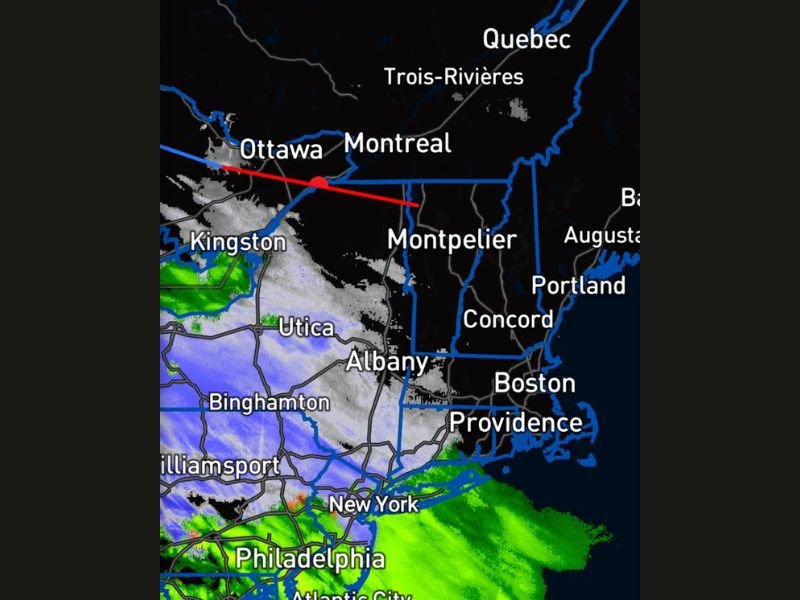
The latest radar imagery shows the core of the snow shield centered over upstate New York, Vermont, New Hampshire, and parts of Maine, while areas farther south are seeing more rain and wintry mix than snow. This warm intrusion is the main factor reducing totals across Massachusetts, Connecticut, and Rhode Island.
Northern New England Still in Line for Accumulation
Despite the warmer surge affecting southern states, northern New England remains cold enough to support measurable snow. Cities such as Montpelier, Burlington, Concord, and Bangor are expected to stay within the main snow band, where colder air is holding steady.
These areas could see steady light to moderate snowfall, especially across higher elevations. Roads may become slick overnight, and drivers are advised to use caution.
Storm Tracking Slightly Faster Than Expected
Forecasters also note that the system is moving faster than earlier models suggested, which further reduces the window for significant snow accumulation. Faster-moving systems have less time to develop strong bands of snow, limiting totals even if temperatures were marginally supportive.
Radar imagery late Monday shows precipitation advancing quickly through New York, Pennsylvania, and northern New England, with the heaviest snow already moving into Quebec and eastern Canada.
What Residents Should Expect
Residents in southern New England should plan for:
- Reduced snowfall totals, likely minimal in many areas
- Mixed precipitation or rain, especially near the coast
- A shorter-duration event, with the system clearing more quickly
Northern areas should still expect steady snow, though totals remain moderate rather than heavy.
The situation will continue to evolve as the storm progresses overnight. Stay with NapervilleLocal.com for continuing updates on regional weather systems and national storm impacts.

I’ve lived in Naperville long enough to see how quickly our community changes — from new developments downtown to sudden shifts in our Midwest weather. Reporting on Naperville news and daily forecasts gives me the chance to keep neighbors informed about what really matters. My goal is simple: deliver clear, timely updates so you always know what’s happening in our city and what to expect from the skies above.