
New Winter System Moves In After First Storm Weakens, Shifting Snow Expectations for Massachusetts, Connecticut, and Rhode Island
United States — A developing winter storm from Canada is drawing renewed attention across the Northeast after the first system of the day weakened substantially, changing snowfall expectations for Massachusetts, Connecticut, and Rhode Island. Radar now shows a stronger, more organized snow shield building to the north as meteorologists monitor which areas may see accumulation overnight.
First Storm Breaks Down Earlier Than Expected
Forecasters described the morning as challenging after the first winter system nearly fell apart, producing far less snow than projected. The rapid weakening forced an immediate shift in forecasting focus, as many residents were preparing for steady snowfall that ultimately did not materialize.
This unexpected collapse has left Massachusetts, Connecticut, and Rhode Island largely outside the main impact zone of the first system. Weather experts emphasize that the disappointment surrounding the initial storm has now placed greater importance on tracking the second system approaching from Canada.
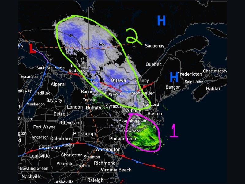
Stronger Second System Approaches from Canada
Radar imagery indicates that the next snow-producing wave is well organized, with widespread snowfall extending across portions of Canada, including areas near Ottawa, Kingston, and Granby. This system is slowly pushing south and is expected to continue shifting toward the northeastern United States through the evening and overnight hours.
Despite its size, the system’s core energy currently remains north of southern New England, meaning Massachusetts, Connecticut, and Rhode Island may not experience the heaviest snowfall. However, the system’s expansive structure leaves room for light snow bands to drift into the region, especially overnight when temperatures drop.
Updated Snow Map Shows Highest Totals North of Southern New England
A newly released snowfall map shows the forecaster is still confident in the morning’s updated projections, despite the first system’s collapse. The highest accumulations are expected well north of Massachusetts, with totals decreasing significantly closer to southern New England.
Projected snowfall includes:
- Heavier bands positioned farther north of the tri-state area
- Lighter accumulations possible along northern Massachusetts
- Minimal accumulation expected for Connecticut and Rhode Island
The forecaster’s message remained consistent: “I am still pretty confident in this morning’s updated snow map, so I am sticking with that at this point.”
What Residents Should Expect Overnight
While this is not a major snow event for the southern New England region, residents should still be prepared for:
- Light, passing snow showers as the second system drifts south
- Reduced visibility in brief, isolated snow bands
- Potential slick spots on untreated roads during the late-night hours
- Quick fluctuations in local conditions depending on the storm’s final track
Meteorologists stress that residents should stay alert, as even small shifts in the storm pattern could influence snowfall amounts.
Stay Informed With Ongoing Weather Coverage
With one system fading and another strengthening, the weather setup across the Northeast remains fluid. Although the primary impacts appear to be north of Massachusetts, Connecticut, and Rhode Island, the situation will continue to be monitored closely. For more weather updates, developing storm coverage, and national forecast insights, visit NapervilleLocal.com.

I’ve lived in Naperville long enough to see how quickly our community changes — from new developments downtown to sudden shifts in our Midwest weather. Reporting on Naperville news and daily forecasts gives me the chance to keep neighbors informed about what really matters. My goal is simple: deliver clear, timely updates so you always know what’s happening in our city and what to expect from the skies above.