
Oregon Braces for Possible Wednesday Windstorm as Models Show Intense Gusts From Eugene to Longview
United States — Weather officials in Oregon are closely monitoring a developing system that could produce a brief but intense windstorm Wednesday morning along the I-5 corridor from Eugene to Longview. Early model projections show the potential for damaging wind gusts, prompting discussion of a First Alert Weather Day if the pattern continues to strengthen.
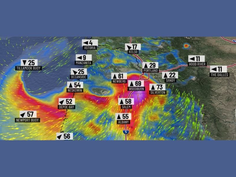
Models Show Strong Wind Potential From Coast to Valley
The latest wind gust map highlights a broad zone of high-impact wind potential stretching from the Oregon coast into the Willamette Valley. Coastal locations such as Depoe Bay, Newport, Neskowin, and Tillamook Buoy show readings between 50 and 57 mph, indicating strong marine exposure.
Farther inland, modeled gusts intensify significantly. Wind values include:
- 73 mph in Silverton
- 69 mph in Woodburn
- 61 mph in Newberg
- 58 mph in Salem
- 55 mph in Albany
- 29 mph in Portland
These values suggest a rapidly developing wind event, particularly in the central valley region, where gusts could approach severe thresholds.
First Alert Weather Day Possible, But Confidence Not Yet Final
Meteorologists caution that while model data is alarming, the event is not yet guaranteed. A First Alert Weather Day has been proposed for the possibility of high winds capable of affecting Christmas Eve and Christmas Day plans if timing or storm intensity shifts.
Forecasters emphasize that the risk is conditional, with confidence expected to increase as new model data arrives. Still, the tone of the early messaging is clear: Oregon residents should prepare for the possibility of strong winds Wednesday morning, especially along the I-5 corridor.
Potential Impacts on the I-5 Corridor
If the modeled scenario materializes, several impacts are possible:
- Hazardous travel due to crosswinds affecting high-profile vehicles
- Power outages from downed trees or broken limbs in wind-prone regions
- Disrupted holiday travel for residents heading out for Christmas-related plans
- Localized property damage in areas where gusts exceed 60–70 mph
Areas between Salem, Woodburn, and Silverton appear most at risk based on current projections, with widespread bright red and purple zones on the wind map indicating the highest modeled gusts.
Forecast Confidence Expected to Improve Overnight
Forecasters are urging residents to follow evening and early-morning updates as models continue refining the storm’s speed and structure. Some runs show a brief but intense burst of wind, while others shift the strongest gusts slightly offshore or further north.
The meteorologist who shared the initial alert noted that highlights from their blog include simplified explanations for readers who prefer to avoid technical forecast terminology. A link to the full update was provided for residents seeking more in-depth analysis.
While uncertainty remains, the message is consistent: Wednesday morning could bring a notable wind event, and preparation is advised. Residents across Oregon should continue to monitor updated forecasts as the system evolves. For ongoing weather coverage, national storm developments, and real-time alerts, visit NapervilleLocal.com.

I’ve lived in Naperville long enough to see how quickly our community changes — from new developments downtown to sudden shifts in our Midwest weather. Reporting on Naperville news and daily forecasts gives me the chance to keep neighbors informed about what really matters. My goal is simple: deliver clear, timely updates so you always know what’s happening in our city and what to expect from the skies above.