
California Upgraded to ‘High Risk’ for Christmas Eve Flash Flooding as NWS Warns of Major Impacts Across Southern SoCal
United States — The National Weather Service has issued a rare and urgent warning for Southern California, upgrading portions of the region to a “high risk” of excessive rainfall and flash flooding on Christmas Eve. The alert covers areas just north of Los Angeles, including Burbank, Altadena, Glendale, San Bernardino, Santa Clarita, and Thousand Oaks, where conditions may deteriorate rapidly as the storm system arrives.
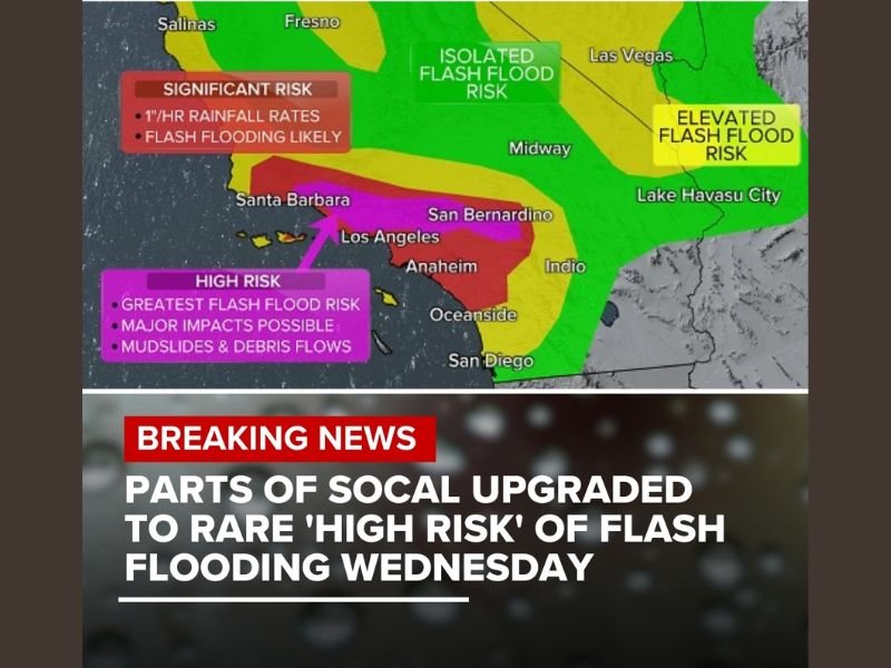
NWS Issues High-Risk Flash Flood Zone for Christmas Eve
This upgraded classification places parts of Southern California in the highest category of flash flood risk, a level the NWS reserves for scenarios where widespread, dangerous flooding is likely. The forecast indicates the potential for intense rainfall rates exceeding 1 inch per hour, which can overwhelm drainage systems and trigger fast-moving floodwaters.
According to meteorologists, a “high risk” designation is extremely uncommon in California, occurring only during significant atmospheric river events or major winter storms capable of producing mudslides, debris flows, and severe runoff in vulnerable areas.
Areas Facing the Greatest Danger
The risk map highlights a wide stretch of Southern California, with the most severe zone concentrated near Los Angeles, Anaheim, San Bernardino, Oceanside, and the surrounding foothill communities. These locations are shaded in bright magenta, marking the areas where flash flooding, mudslides, and infrastructure impacts are most likely.
Other surrounding regions — including areas from Santa Barbara to San Diego — fall within the broader risk zone, experiencing elevated but slightly less severe threats. Residents living near burn scars, steep terrain, or canyon roads are being urged to take precautions immediately.
A related report from ABC7, referenced by officials, underscored the seriousness of the forecast: extreme rainfall could disrupt holiday travel and potentially impact Christmas Eve and Christmas Day plans if conditions worsen further. (Link provided in original source: abc7.la)
Significant Rainfall Could Lead to Mudslides and Debris Flows
Forecasters warn that the combination of saturated soils, steep hillsides, and heavy rainfall rates could generate fast-moving debris flows in vulnerable communities. These hazards can occur with little warning, especially at night or during periods of intense rainfall. Models currently show a powerful moisture plume pushing into coastal and valley areas, producing:
- Sudden roadway flooding in low-lying neighborhoods
- Rapid rises in creeks and storm channels
- Mudslides in foothill communities such as Altadena, Glendale, and San Bernardino
- Travel delays and possible road closures due to washouts or debris
Emergency responders across Southern California are preparing for potential evacuations in high-risk locations.
Residents Urged to Monitor Conditions Closely
While the exact rainfall totals will evolve as the storm approaches, the NWS emphasizes that the high-risk classification itself is a signal of potentially life-threatening flooding conditions. Residents are encouraged to stay aware of local alerts, avoid driving through flooded roadways, and prepare for sudden weather changes on Christmas Eve.
Forecasters stress that although the storm is significant, its exact intensity remains dependent on how the incoming moisture band interacts with local terrain. Updated guidance will continue through the week as the system approaches Southern California. For continuing coverage of national weather threats, storm tracking, and regional alerts, stay connected with NapervilleLocal.com.

I’ve lived in Naperville long enough to see how quickly our community changes — from new developments downtown to sudden shifts in our Midwest weather. Reporting on Naperville news and daily forecasts gives me the chance to keep neighbors informed about what really matters. My goal is simple: deliver clear, timely updates so you always know what’s happening in our city and what to expect from the skies above.