
Dangerous Winter Storm to Disrupt Holiday Travel Across Pennsylvania Friday Afternoon Through Overnight, With Ice Storm Threat and Heavy Snow
Pennsylvania – A significant winter storm is expected to impact Pennsylvania from Friday afternoon through the overnight hours, creating dangerous travel conditions during a busy holiday travel period. Forecast guidance favors a northerly storm track, which increases the likelihood of widespread freezing rain and ice accumulation in central Pennsylvania, while heavier snowfall is more likely in northeastern and far eastern parts of the state. The storm’s complex setup means many communities will experience multiple precipitation types, making impacts harder to manage and predict.
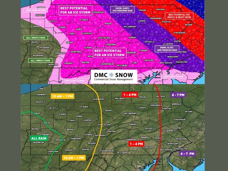
Highest Ice Storm Risk in Central Pennsylvania
The greatest concern centers on central Pennsylvania, where conditions strongly favor freezing rain for an extended period. Cities and towns including State College, Altoona, Clearfield, Dubois, Lewistown, Harrisburg, and surrounding communities fall within the zone labeled as having the best potential for an ice storm.
Ice accumulation on untreated roads, bridges, trees, and power lines could lead to dangerous driving conditions, scattered power outages, and tree damage. Ice storms are particularly hazardous because even small amounts of ice can significantly increase accident and outage risks.
Heavy Snow Potential in Northeastern and Far Eastern Areas
In contrast, northeastern and far eastern Pennsylvania are more likely to see mostly snow, with moderate to heavy snowfall rates possible. Areas near Scranton, Milford, and surrounding regions could experience rapidly deteriorating travel conditions as snowfall intensifies Friday evening and overnight. Between the ice-dominated central region and the snowier eastern zone, a transition corridor of snow, sleet, and freezing rain is expected, adding further uncertainty and travel hazards.
Western Pennsylvania Mostly Rain
Southwestern and far western Pennsylvania are expected to see mainly rain, with temperatures warm enough to limit winter impacts in those areas. However, light icing remains possible near the northern edge of the rain zone, especially during the early stages of the storm. While impacts here should be less severe, changing conditions could still cause localized travel issues.
Timing and Travel Concerns
Timing is a key factor with this storm. Wintry precipitation is expected to spread from west to east across Pennsylvania on Friday, beginning late morning in the west, early to mid-afternoon in central regions, and late afternoon to early evening in the east.
Once precipitation begins, conditions are expected to deteriorate quickly, especially where freezing rain or heavy snow develops. Forecasters strongly recommend avoiding travel Friday afternoon and evening. Those who can adjust plans are advised to travel Thursday or Saturday instead.
Why This Matters Beyond Pennsylvania
For residents of the Midwest, including Naperville and the greater Chicago area, this storm is important for anyone traveling to or from Pennsylvania. Flight delays, road closures, and power outages in the region could create ripple effects across the holiday travel network. Staying informed and flexible will be essential as this impactful winter storm approaches.

I’ve lived in Naperville long enough to see how quickly our community changes — from new developments downtown to sudden shifts in our Midwest weather. Reporting on Naperville news and daily forecasts gives me the chance to keep neighbors informed about what really matters. My goal is simple: deliver clear, timely updates so you always know what’s happening in our city and what to expect from the skies above.