
California Under High-Risk Flood Alert as Powerful Storm Threatens 7 Inches of Rain and Catastrophic Flooding
United States — A powerful Pacific storm is forecast to deliver very heavy rainfall across Southern California, prompting a high-risk flood alert and warnings of potentially catastrophic flooding. Meteorologists warn that the storm will produce intense rainfall over a concentrated 18-hour window, with conditions likely to deteriorate rapidly once the system arrives.
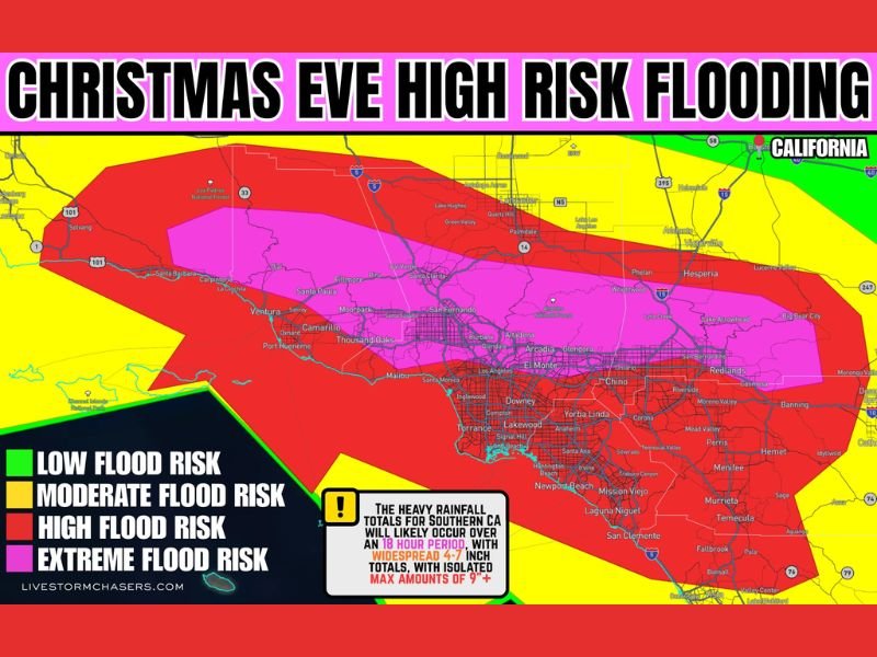
High-Risk Flood Designation Issued for Southern California
Weather authorities have placed Southern California under a high-risk flood threat, the most serious category for flash flooding and widespread inundation. This designation is typically reserved for events where major impacts are likely, including rapid road flooding, mudslides, and dangerous debris flows.
Forecast models show:
- Widespread rainfall of 4–7 inches
- Isolated totals exceeding 9 inches
- Rainfall rates between 0.5 and 1.5 inches per hour
These values significantly elevate the risk for flash flooding due to the storm’s intensity and short duration. Although the region normally experiences minimal precipitation this time of year, this system is expected to bring tropical-like rainfall rates capable of overwhelming drainage systems quickly.
Strong South-to-North Rain Band Expected to Drive Extreme Rainfall
One of the most concerning features of the storm is a strong south-to-north rain band expected to set up across the region. This narrow but potent corridor will deliver persistent and intense rainfall, particularly in areas aligned directly beneath the moisture flow.
Meteorologists caution that when rainfall rates approach or exceed one inch per hour, flooding can develop rapidly. This risk is amplified during an 18-hour event, where sustained heavy rain leaves little time for water to recede.
The orientation of this rain band also increases the chance of localized flash flooding, especially in neighborhoods situated near small creeks, drainage basins, and low-lying intersections prone to water pooling.
Burn Scar Areas and Dry Ground Increase Flood Danger
Southern California’s landscape adds further risk to this developing storm. Large portions of the region are dealing with very dry ground following recent extended dry periods. While dry soil might seem beneficial, it actually makes the situation worse; hardened ground prevents water from soaking in, causing rainfall to run off rapidly.
Recent wildfire burn scars also pose a significant threat. Locations impacted by recent fires are especially vulnerable to:
- Debris flows
- Mudslides
- Rapid hillside erosion
- Sudden surges of mud and rock
Even moderate rainfall can trigger dangerous conditions in these zones, and with projected totals exceeding several inches, the danger intensifies. Emergency responders and forecasters emphasize that residents near burn scar areas should be prepared for rapid evacuations, as debris flows can occur with little warning and travel at high speed.
Residents Urged to Prepare for Rapidly Changing Conditions
Officials are urging Southern California residents to stay alert as the storm approaches. With rainfall intensifying over a short period, road conditions may change quickly, and flooding can occur even in areas that typically remain dry.
Residents should be prepared for:
- Road closures and delays
- Potential power outages
- Hazardous nighttime driving conditions
- Water accumulation around homes and businesses
Meteorologists stress that high-risk flood events should be taken seriously, as they often result in widespread disruption and significant damage. Updated forecasts and alerts will continue as new data becomes available. For ongoing national weather coverage, storm updates, and impact forecasts, stay connected with NapervilleLocal.com.

I’ve lived in Naperville long enough to see how quickly our community changes — from new developments downtown to sudden shifts in our Midwest weather. Reporting on Naperville news and daily forecasts gives me the chance to keep neighbors informed about what really matters. My goal is simple: deliver clear, timely updates so you always know what’s happening in our city and what to expect from the skies above.