
Pennsylvania Under Rare Ice Storm Warning as NWS Alerts 17 Counties to Life-Threatening Road Conditions and Possible Power Outages
Pennsylvania — The National Weather Service has issued a rare Ice Storm Warning for 17 counties across Pennsylvania, warning residents that travel may become impossible at times due to dangerous ice accumulation on roads, bridges, trees, and power lines. Officials are urging residents to avoid all travel on Friday as post-holiday traffic could coincide with extremely hazardous conditions.
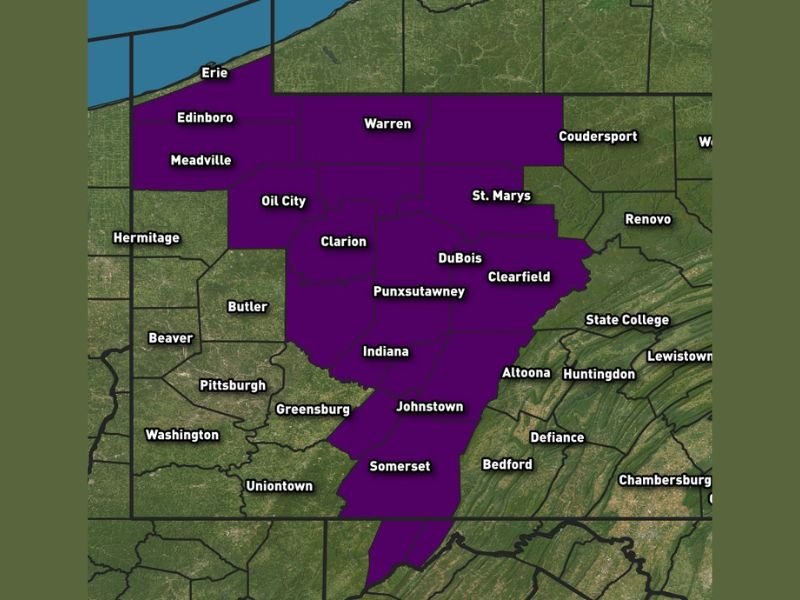
The counties included in the warning are: Armstrong, Cambria, Clarion, Clearfield, Crawford, Elk, Forest, Indiana (including higher elevations), Jefferson, McKean, Somerset, southern Erie, Venango, Warren, and the Westmoreland Ridges.
Significant Ice Accumulation Expected to Create Extremely Dangerous Travel Conditions
Forecasters warn that roadways — especially bridges and overpasses — may become slick, hazardous, and nearly impassable due to widespread freezing rain. Because elevated surfaces freeze first, drivers may encounter ice without warning, even if surrounding pavement appears wet.
The rare nature of the warning underscores the seriousness of this system. Ice buildup on trees, roofs, and power lines is expected, with tree damage and scattered power outages likely as freezing rain intensifies through the morning and early afternoon.
Meteorologists stress that travel could become impossible for several hours, particularly in higher elevations such as the Westmoreland Ridges, Indiana County highlands, and Somerset County. Anyone on the roads during peak icing may face dangerously reduced traction, limited visibility, and sudden roadway glazing.
Areas Most at Risk for Severe Ice Impacts
Based on the alert zone, several regions of Pennsylvania are at heightened risk:
- Northwestern counties: Crawford, Erie (southern portion), Warren
- Central counties: Clearfield, Jefferson, Clarion, Forest
- Western and southwestern counties: Indiana, Cambria, Somerset, Westmoreland Ridges
- Northern tier counties: McKean, Elk
These regions fall within the zone expected to receive the highest ice accumulation, potentially reaching levels where tree limbs snap, power lines sag, and road crews struggle to keep up with rapidly forming ice. Officials emphasize that even moderate icing can create severe hazards, but the warning issued today reflects the potential for more substantial, disruptive ice totals.
NWS Urges Residents to Stay Home and Spread the Warning
The National Weather Service delivered an urgent message:
Do not travel if you are in the warning area.
Hazardous conditions are expected to peak Friday morning through early afternoon. Those who must travel for emergency reasons are advised to:
- Check road conditions before leaving
- Carry a charged phone and emergency kit
- Reduce speed significantly
- Avoid bridges and untreated rural roads
Meteorologists and emergency managers are asking the public to share the warning widely to ensure friends, neighbors, and relatives are aware of the life-threatening travel risks.
Ice Storm Expected to Impact Post-Holiday Travel Across Pennsylvania
With many residents still traveling after Christmas celebrations, the timing of this storm raises additional concerns. Post-holiday commuters may encounter rapidly deteriorating road conditions, with ice forming faster than crews can respond.
Officials recommend postponing any planned travel until after the warning expires and conditions improve. Melting should begin later in the day once surface temperatures rise, but residual slick spots may remain into the evening. For real-time Pennsylvania weather alerts, safety updates, and severe storm coverage, stay with NapervilleLocal.com for accurate and timely reporting.

I’ve lived in Naperville long enough to see how quickly our community changes — from new developments downtown to sudden shifts in our Midwest weather. Reporting on Naperville news and daily forecasts gives me the chance to keep neighbors informed about what really matters. My goal is simple: deliver clear, timely updates so you always know what’s happening in our city and what to expect from the skies above.