
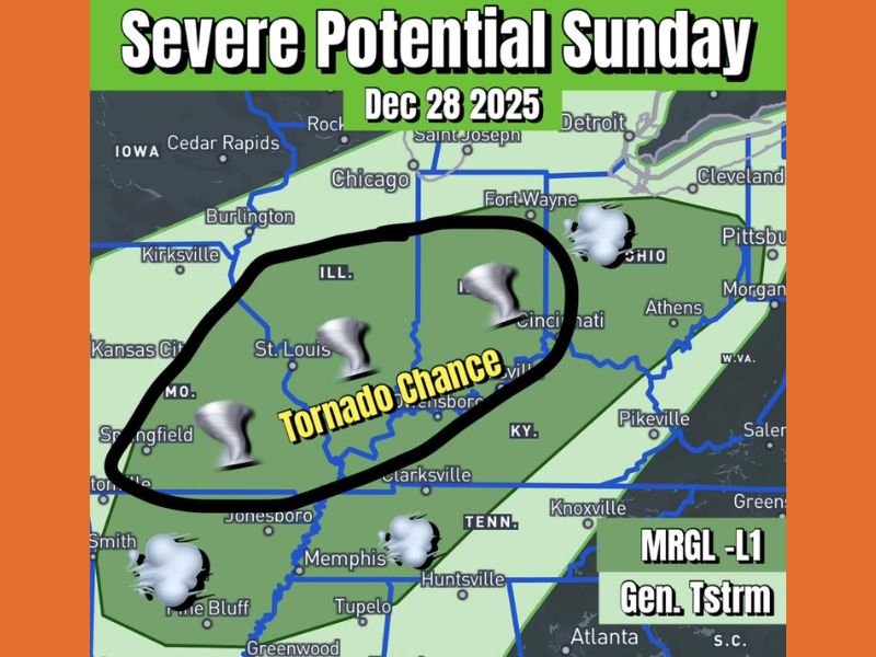
Illinois, Missouri, Indiana, Kentucky and Ohio Face Marginal Severe Weather Risk Sunday With Possibility of Damaging Gusts and a Brief Tornado
ILLINOIS — A fast-moving storm system is expected to sweep across the Midwest on Sunday, December 28, 2025, bringing a Level 1 (Marginal) severe weather risk to portions of Illinois, Missouri, Indiana, Kentucky and Ohio. Forecasters say the threat is limited but not zero, as conditions may briefly support isolated severe thunderstorms capable of strong wind gusts and potentially a brief, weak tornado.
Storm System Moving Quickly Across the Region
Meteorologists note that this system will move rapidly, which helps limit the overall severity. However, the speed also means that moisture and instability will be pulled northward quickly, allowing thunderstorms to develop in a narrow window of favorable conditions.
The risk area stretches across a large portion of the central Midwest, including cities such as St. Louis, Springfield (MO), Evansville, Cincinnati, and parts of southern Illinois and Indiana.
Key risk details include:
- Severe risk level: Level 1 (Marginal)
- Primary hazards: Damaging wind gusts
- Tornado potential: Low but possible
- Timing: Sunday, December 28, 2025
Why the Tornado Chance Exists Despite Low Risk
A Marginal Risk does not mean severe weather is expected everywhere. Instead, it indicates that most storms will stay below severe limits.
Meteorologists caution that there is just enough instability for a few storms to briefly intensify as the cold front approaches. The strongest storms may rotate weakly, especially in the zone highlighted over southern Illinois, eastern Missouri, southern Indiana, northern Kentucky, and southwest Ohio. This area is marked as having a “Tornado Chance” in the latest outlook.
Damaging Wind Gusts Remain the Main Concern
Even if tornadoes remain unlikely, straight-line winds can still cause disruptions. Fast-moving storms may produce pockets of strong gusts capable of knocking down tree limbs, damaging outdoor items, or creating difficult travel conditions.
Because the system will move quickly, any storm that becomes severe will likely be short-lived. Still, residents within the highlighted risk zone should remain alert through the afternoon and evening.
Potential impacts include:
- Localized wind damage
- Sudden storm development along the cold front
- Brief periods of heavy rain
- Isolated tornado risk in the circled region
Communities Urged To Stay Alert As Storms Move Through
While this is not a widespread severe weather outbreak, even a low-end risk can create problems, especially when storms move quickly across multiple states. Emergency officials encourage residents to monitor weather updates closely. Marginal-risk days have produced impactful storms in the past when ingredients come together briefly.
Residents traveling on major routes such as I-55, I-64, I-70, and I-75 may encounter fast-moving storms as the front passes. Rural areas may also experience reduced visibility, making it harder to spot brief tornadoes.
What Residents Should Do Today
Forecasters recommend simple precautions as the system approaches. Keeping devices charged and ensuring that weather alerts are enabled can help residents receive timely warnings. Outdoor items that can blow away should be secured, and travel plans should include flexibility in case storms develop.
Basic safety reminders:
- Enable emergency alerts on phones
- Monitor updated forecasts through the day
- Protect vehicles and loose outdoor items
- Stay prepared for quick weather changes
More Updates Coming As System Approaches
Meteorologists will refine the forecast as additional data becomes available. Although the overall threat remains limited, the combination of damaging winds and a brief tornado possibility warrants attention. Stay with NapervilleLocal.com for continuing updates and statewide coverage as this weather system moves across the Midwest.

I’ve lived in Naperville long enough to see how quickly our community changes — from new developments downtown to sudden shifts in our Midwest weather. Reporting on Naperville news and daily forecasts gives me the chance to keep neighbors informed about what really matters. My goal is simple: deliver clear, timely updates so you always know what’s happening in our city and what to expect from the skies above.