
Michigan, Minnesota, and Wisconsin Under Blizzard Warnings as 1–3 Feet of Snow and 75 MPH Winds Threaten Major Travel Disruptions
MICHIGAN — A powerful winter storm is impacting Michigan, Minnesota, and Wisconsin, where blizzard warnings have been issued ahead of extremely hazardous conditions. Forecasters warn that this system may produce some of the strongest winter impacts so far this season, with the potential for deep snow, dangerous winds, and widespread road closures.
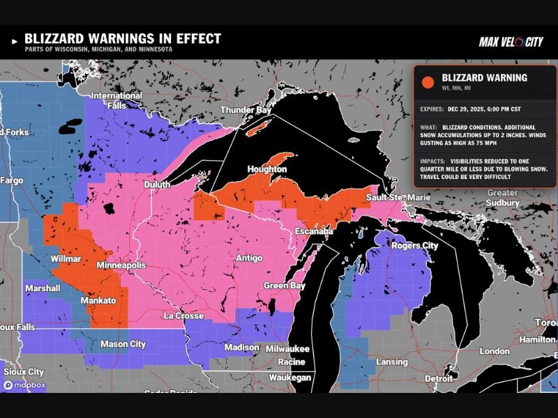
Blizzard Conditions Expected Across the Upper Midwest
The storm is already spreading heavy snow into Minnesota and Wisconsin, with Michigan’s Upper Peninsula facing some of the highest totals. Blizzard conditions are expected to intensify as the system strengthens, bringing reduced visibility and life-threatening travel scenarios across multiple states.
Key storm figures:
- Snow totals: 1–3 feet possible
- Wind gusts: Up to 75 mph
- Blizzard Warning expiration: Dec 29, 2025, at 6:00 PM CST
Travel May Become Impossible in Hardest-Hit Zones
Meteorologists warn that the combination of deep snow and intense winds will make travel extremely dangerous. Visibility may drop to near zero at times as blowing snow creates whiteout conditions, even in areas with lighter snowfall amounts.
Major interstates and rural highways across Minnesota and Wisconsin are expected to see closures if conditions deteriorate further. Areas such as Minneapolis, Duluth, La Crosse, Green Bay, and the central Upper Peninsula are highlighted as high-impact zones on the storm map.
Upper Peninsula Faces Highest Snowfall Potential
Snowfall projections show the Upper Peninsula of Michigan at risk of the most extreme totals, driven by lake enhancement and persistent banding. This region may experience near-continuous snowfall and rapidly drifting snow as winds intensify through the storm’s peak hours.
Communities like Marquette, Houghton, Escanaba, and Sault Ste. Marie are likely to see significant disruptions, with emergency managers already urging residents to avoid all unnecessary travel.
Wind Gusts Could Exceed Hurricane Strength in Some Areas
One of the most dangerous aspects of this storm is the wind. Forecasts show gusts reaching levels comparable to weak hurricanes. These powerful winds will pick up loose snow and create blinding whiteouts, even long after heavy snowfall ends.
Wind-related impacts:
- Visibility reduced to ¼ mile or less
- Dangerous wind chills possible
- Increased risk of power outages and downed trees
Residents Urged to Prepare for Prolonged Disruptions
Officials across the region are asking residents to complete preparations quickly. Power outages, road closures, and emergency service delays are all likely. Those in rural areas face additional risks due to drifting snow and limited visibility.
People are encouraged to charge devices, stock essential supplies, and avoid all non-essential travel until the blizzard warnings expire. Even after the storm passes, cleaning up roadways may take considerable time.
More Updates Coming as Blizzard Continues to Strengthen
Forecasters say the storm still has room to intensify, and warning areas may expand if snowfall bands shift. The next 24 hours will be critical as the heaviest snow and strongest winds align across Michigan, Minnesota, and Wisconsin. Stay with NapervilleLocal.com for ongoing weather updates, travel warnings, and late-breaking forecasts as this blizzard unfolds across the Upper Midwest.

I’ve lived in Naperville long enough to see how quickly our community changes — from new developments downtown to sudden shifts in our Midwest weather. Reporting on Naperville news and daily forecasts gives me the chance to keep neighbors informed about what really matters. My goal is simple: deliver clear, timely updates so you always know what’s happening in our city and what to expect from the skies above.