
Indiana Faces Power Outage Risk Sunday Night Into Monday as Strong 45–55 MPH Winds Sweep Across the State
INDIANA — Strong winds behind an incoming cold front may bring scattered power outages across Indiana late Sunday night into Monday. Unlike severe weather outage maps, this forecast highlights outages caused specifically by non-thunderstorm wind gusts, which will intensify as colder air pushes into the region.
Strong Winds Expected to Sweep Across Indiana
Forecasters warn that west and northwest winds will strengthen Sunday night and continue through Monday morning. The most significant gusts are expected in northern Indiana and areas closer to Lake Michigan, where exposure is greatest.
Wind figures from the forecast:
- Statewide gusts of 45–55 mph
- Higher gusts possible near Lake Michigan
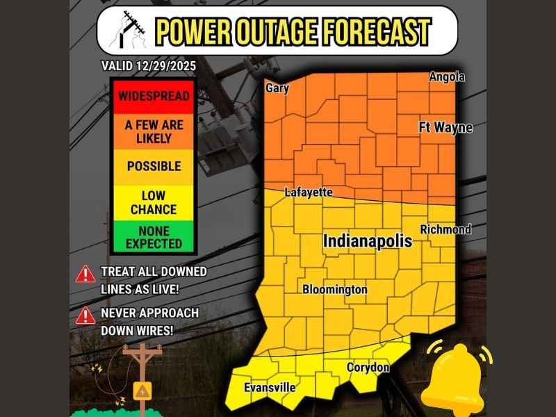
- Outage risk valid December 29, 2025
Northern Indiana at Highest Risk for Power Disruptions
A detailed outage forecast map shows the northern half of Indiana — including Gary, Angola, Fort Wayne, and Lafayette — under a category where “a few outages are likely.” These areas are more vulnerable due to stronger gusts and higher tree density.
Central regions including Indianapolis, Bloomington, and Richmond fall under a “possible” outage zone, meaning scattered issues could occur depending on wind strength and local impacts.
Southern Indiana Sees Lower Risk but Not Zero
Cities such as Evansville and Corydon are positioned in the lower-impact category, where the chance for outages is reduced but still present. Wind speeds will remain elevated statewide, which means even southern counties should monitor changing conditions. While the overall risk decreases the farther south you go, the entire state will experience breezy to windy conditions throughout Monday.
Powerline Safety Emphasized Ahead of the Wind Event
Officials urge residents to treat all downed power lines as dangerous. Even a line that appears inactive may still carry voltage, particularly during wind-related outages when power companies are working on repairs.
Safety reminders:
- Treat every downed line as live
- Never approach or drive over a downed wire
- Report outages and hazards immediately to local authorities
Residents Encouraged to Prepare Before Winds Peak
The combination of elevated gusts, loose tree branches, and saturated ground from recent weather could increase the risk of lines being knocked down. Residents are encouraged to secure outdoor items, charge devices, and prepare for brief outages. Monday morning travel may also be affected in open areas, where crosswinds can make driving more difficult.
More Updates Expected as Forecasts Adjust
Meteorologists will continue monitoring wind speed trends to determine whether advisories or warnings will be issued. Winds could fluctuate depending on the cold front’s timing, and updated guidance may follow. Stay with NapervilleLocal.com for real-time updates, safety alerts, and statewide weather coverage as these strong winds move across Indiana.

I’ve lived in Naperville long enough to see how quickly our community changes — from new developments downtown to sudden shifts in our Midwest weather. Reporting on Naperville news and daily forecasts gives me the chance to keep neighbors informed about what really matters. My goal is simple: deliver clear, timely updates so you always know what’s happening in our city and what to expect from the skies above.