
Illinois Set for Extreme 50–70 Degree Temperature Crash From Sunday to Monday, With Wind Chills Dropping Below Zero
ILLINOIS — A dramatic temperature crash is set to sweep across Illinois from Sunday afternoon into Monday morning, bringing one of the sharpest drops of the season. Forecasters warn that conditions will shift from “spring-like” to frigid in less than 24 hours, raising the risk of a flash freeze across parts of the state.
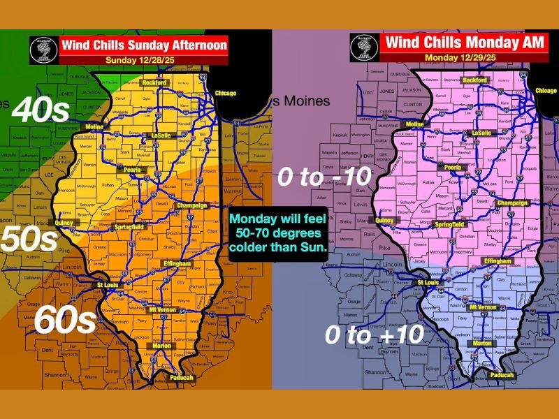
Sunday’s Mild Conditions Will Collapse Overnight
On Sunday, much of Illinois will feel unusually warm for late December, with real-feel temperatures mimicking early spring. Many areas in central and southern Illinois may feel like the 60s heading into the afternoon.
Real-feel temperatures Sunday:
- 40s in northern Illinois
- 50s in central Illinois
- 60s in southern Illinois
Actual air temperatures will also be in the same range, creating a false sense of comfort before the incoming cold front arrives.
Wind Chills Plunge Below Zero by Monday Morning
By early Monday, the entire state will undergo a sharp reversal. Wind chills will fall below zero for many locations, with actual air temperatures only in the single digits and teens.
Monday morning values:
- Wind chills: 0 to –10°F across northern and central Illinois
- Wind chills: 0 to +10°F across southern Illinois
- Actual air temperatures: 5–15°F
This represents an extraordinary 50–70 degree temperature drop in a very short period of time.
Flash Freeze Possible as Temperatures Crash
Forecasters caution that the rapid shift from above-freezing to below-freezing temperatures may trigger a flash freeze in certain areas. Even small amounts of leftover moisture on pavement can rapidly turn to ice as temperatures collapse overnight.
Residents are encouraged to monitor conditions closely, especially if rain or melting snow precedes the temperature drop. Roads that appear simply wet may freeze quickly as cold air pushes in.
Monday Will Feel Bitterly Cold Across the State
The abrupt transition will make Monday one of the coldest-feeling days so far this winter. Even with limited snowfall involved, the wind chills alone will create hazardous conditions for anyone spending extended time outdoors. Commuters should plan on dressing in full winter gear and allowing extra travel time, particularly during the early-morning hours when temperatures will be at their lowest.
Key impacts to expect:
- Extremely cold wind chills
- Hazardous travel during Monday morning commute
- Risk of black ice from a flash freeze
- Rapid onset of winter conditions
Residents Encouraged to Prepare Ahead of the Drop
The National Weather Service and local meteorologists recommend preparing now for the dramatic shift. Anyone traveling Sunday evening into Monday morning should be aware of the potential for ice and dangerous cold. Outdoor pets, pipes, and sensitive equipment should be protected before temperatures plunge. The abrupt cold may also stress vehicles, so checking batteries and fuel levels is advised.
More Updates Coming as the Front Approaches
Meteorologists will continue refining the timing of the drop as new data becomes available. Even slight shifts could influence where and when a flash freeze develops. Stay with NapervilleLocal.com for updated timing, wind chill forecasts, and statewide cold-weather alerts as this temperature crash moves through Illinois.

I’ve lived in Naperville long enough to see how quickly our community changes — from new developments downtown to sudden shifts in our Midwest weather. Reporting on Naperville news and daily forecasts gives me the chance to keep neighbors informed about what really matters. My goal is simple: deliver clear, timely updates so you always know what’s happening in our city and what to expect from the skies above.