
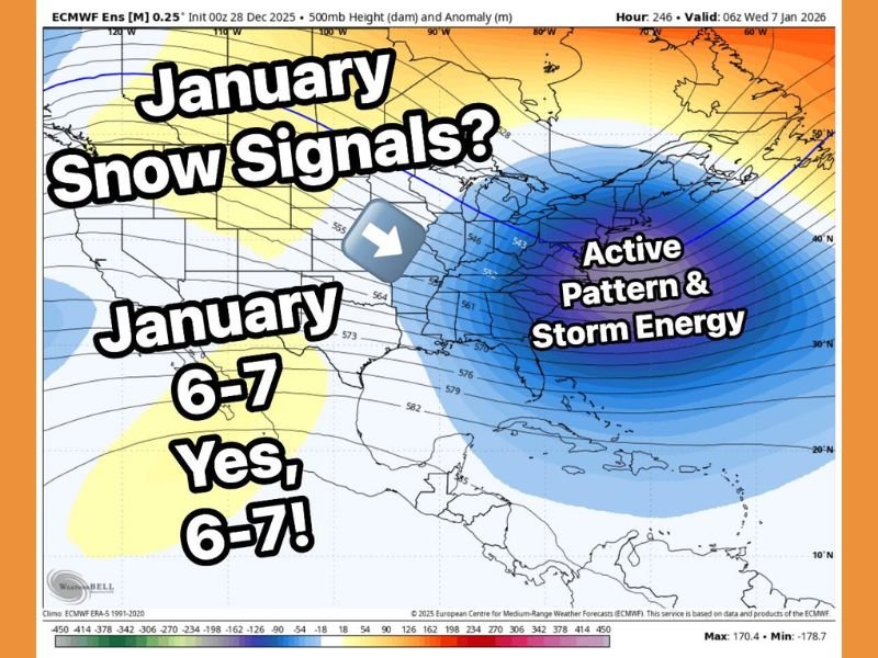
Early January Weather Models Hint at Possible Snow on January 6–7, but Forecast Remains Uncertain
UNITED STATES — Early long-range weather models are showing hints of possible snowfall around January 6–7, but meteorologists caution that confidence remains very low and nothing close to a confirmed forecast. Both the GFS and European model briefly suggested the possibility of around 6–7 inches of snow before dropping the signal entirely in later updates. Forecasters say this kind of fluctuation is normal at long range and should not be interpreted as a reliable projection. The early model swings simply indicate that the atmosphere is active, not that a storm is locked in for early January.
Cold Air Returning May Create Opportunities for Snow
Meteorologists expect colder air to return during the opening days of January. This shift is important because it can create a favorable environment for wintry weather if moisture and storm energy arrive at the same time.
However, that alignment is uncertain. Long-range forecasts are extremely volatile, especially when cold air and storm tracks have not yet locked into position. Forecasters note that while the pattern looks “interesting,” it is far too early to expect a measurable snow event from it. If these early signals continue appearing in multiple model runs, confidence may slowly increase. For now, the setup remains in a watch-and-wait stage.
No Significant Snow Threat Yet for Early January
Based on current data, there is no significant or confirmed snow threat for southern regions through the first weekend of January. Early maps may show patches of potential snowfall, but these signals have not held steady.
Forecasters emphasize that the back half of January looks more promising. After MLK weekend, colder air could settle more firmly into the region, and storm energy may become more organized. This combination often leads to more reliable snow chances compared to early-month setups. If any impactful snowfall occurs in January, meteorologists believe it is more likely to happen later in the month rather than during the January 6–7 window.
Why Confidence Remains Low in Long-Range Snow Forecasts
Long-range snowfall projections frequently shift because the atmosphere is still organizing several key pieces of the pattern. Forecast confidence will only increase when models begin showing stability in areas such as:
- Consistent storm track placement
- A clearer location of incoming cold air
- Strengthening moisture indicators
Until these factors align, the January 6–7 signal remains a developing possibility, not a dependable forecast. Meteorologists expect several adjustments in the coming days as new model data becomes available.
January Outlook Suggests a More Active Winter Pattern
Even though early January may not deliver significant snowfall, the overall month appears likely to be more active than December. Colder temperatures and increasing atmospheric energy could support multiple systems during the second half of the month.
Residents should expect frequent model updates, shifting predictions, and growing discussion about possible winter storm setups as January progresses. The pattern is becoming more energetic, which often leads to better snowfall chances once the atmosphere becomes fully aligned.
As forecasts evolve, NapervilleLocal.com will continue tracking the January 6–7 window along with the broader winter outlook. Check back regularly for updated model trends, new storm signals, and reliable winter weather coverage tailored for local readers.

I’ve lived in Naperville long enough to see how quickly our community changes — from new developments downtown to sudden shifts in our Midwest weather. Reporting on Naperville news and daily forecasts gives me the chance to keep neighbors informed about what really matters. My goal is simple: deliver clear, timely updates so you always know what’s happening in our city and what to expect from the skies above.