
Tornado Watch Issued for Illinois, Indiana, Kentucky, and Missouri as Severe Storm System Brings Tornado, Hail, and High-Wind Threats
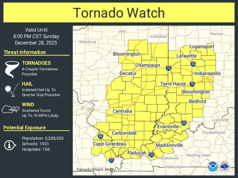
ILLINOIS — A tornado watch is in effect through 8 PM CST as severe storms threaten large portions of Illinois, Indiana, Kentucky, and Missouri with tornado potential, damaging hail, and wind gusts reaching up to 75 miles per hour. Millions across the central U.S. are under alert as atmospheric conditions become increasingly supportive of rotating thunderstorms and fast-moving severe weather.
Weather officials caution that storms may intensify quickly during the late afternoon and evening hours, creating conditions that could produce a couple of tornadoes across the watch area. The threat zone extends across a major stretch of the Midwest and Ohio Valley, emphasizing the widespread nature of this event.
Over 5 Million Residents Affected Across the Multi-State Watch Area
National Weather Service data shows more than 5.2 million people are included in this tornado watch. This expansive region covers Bloomington, Champaign, Decatur, Terre Haute, Evansville, Cape Girardeau, Paducah, and numerous surrounding communities. With such a broad population at risk, emergency officials stress the need for high awareness and rapid response readiness.
The watch zone also includes 1,931 schools and 156 hospitals, highlighting how crucial quick communication and safety planning will be. Severe storms in this setup can strengthen rapidly, leaving residents with very limited time to act once warnings are issued.
Tornadoes, Quarter-Size Hail, and 75 MPH Winds Possible
According to the tornado watch bulletin, a couple of tornadoes are possible, meaning conditions support rotating storms that could produce brief but damaging tornado touchdowns.
Additionally, forecasters warn of isolated hail up to quarter size, which can cause roof, vehicle, and window damage in stronger cells.
Wind gusts up to 75 miles per hour are also likely across parts of the region. Such winds can down trees, damage power lines, and make driving hazardous—especially for high-profile vehicles. Even non-tornadic storms are capable of producing destructive wind pockets under these conditions.
Storm Timing Extends Through Sunday Evening
The watch remains active until 8 PM CST (9 PM ET), covering the peak time frame for severe thunderstorm development. Storms are expected to move eastward throughout the evening, with new cells forming along the advancing cold front.
Residents should anticipate heavy rain, sudden drops in visibility, frequent lightning, and shifting wind patterns. Rural and open areas may experience wind-driven debris, while urban regions could face brief but intense rainfall and downed branches.
Meteorologists recommend keeping mobile alerts activated and ensuring multiple ways to receive warnings, particularly for people traveling or outdoors.
Officials Urge Residents to Prepare for Rapid Changes
Emergency managers advise identifying safe shelter locations now rather than waiting for a warning. Even a brief tornado touchdown can cause localized but serious damage, making quick action essential. Securing outdoor items, charging devices, and avoiding unnecessary travel will help reduce risks as the evening progresses.
As severe weather continues across the Midwest, NapervilleLocal.com will provide real-time updates, warning alerts, and evolving forecast information. Check back for continued coverage as this dangerous storm system moves across Illinois, Indiana, Kentucky, and Missouri.

I’ve lived in Naperville long enough to see how quickly our community changes — from new developments downtown to sudden shifts in our Midwest weather. Reporting on Naperville news and daily forecasts gives me the chance to keep neighbors informed about what really matters. My goal is simple: deliver clear, timely updates so you always know what’s happening in our city and what to expect from the skies above.