
Florida Braces for Unusually Cold New Year’s Morning as Wind Chills Drop Into the 30s Across the Peninsula
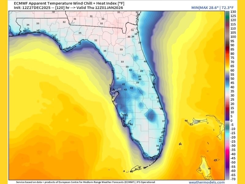
FLORIDA — Wind chill forecasts show a rare and unusually cold New Year’s morning across the state, with apparent temperatures expected to fall into the upper 30s and low 40s across central and southern regions, and even colder readings across the panhandle. The latest ECMWF model image highlights widespread blue shading over the peninsula, signaling a sharp departure from the warm conditions Florida typically sees this time of year.
Forecasters note that wind chills could reach the low-to-mid 30s in many inland communities, with coastal locations feeling only slightly warmer. The broad reach of the cold air suggests one of the chilliest starts to a new year Florida has experienced in several winters.
Wind Chills in the 30s Expected From Tampa Bay to Central Florida
Model projections show apparent temperatures around 37–43 degrees in the Tampa Bay region early Thursday morning. Inland areas may fall closer to the mid-30s, especially where winds remain steady overnight. While these values may be typical for northern states, they represent a notable cold snap for Floridians used to mild holiday mornings.
Central Florida communities also see widespread 30s in the forecast, with Orlando and nearby cities dipping into the upper 30s before sunrise. Even parts of southern Florida appear unlikely to escape the chill entirely, with projected wind chills in the low-to-mid 40s. The extent of the cold air suggests that nearly the entire peninsula will experience a meaningful drop in comfort levels on New Year’s morning.
Panhandle and North Florida See the Coldest Readings
Northern parts of the state are expected to feel the strongest effects of the approaching air mass. Forecast maps show readings around 30–33 degrees in Tallahassee, Pensacola, and surrounding areas. These apparent temperatures reflect a blend of cooler air and steady northerly winds that will continue overnight.
While the event does not currently pose widespread freeze concerns, the cold wind will make conditions feel significantly harsher than the actual temperatures, especially for early travelers or outdoor workers. Any sheltered or low-lying areas may experience slightly colder pockets of air before sunrise.
Cold Morning Will Give Way to a Gradual Warm-Up
Despite the chilly start, daytime temperatures will recover gradually through New Year’s Day. Sunshine and weakening winds will help lift afternoon readings into the upper 50s and low 60s across central and northern Florida, with slightly warmer values farther south.
Still, the early-morning chill may come as a surprise to many residents, particularly those vacationing in Florida expecting warmer holiday weather. Pet owners, outdoor workers, and early commuters should prepare for conditions that feel more like northern states than the Sunshine State.
Residents Encouraged to Prepare for the Unseasonable Chill
Meteorologists recommend dressing in layers for early-morning activities and keeping an eye on wind speeds that may enhance the cold. Those living in areas with sensitive plants may want to take light protective measures overnight, although a widespread freeze is not anticipated.
As Florida experiences this rare New Year’s cold snap, NapervilleLocal.com will continue monitoring updates, new model trends, and the broader weather pattern affecting the southeastern United States. Check back for expanded coverage and additional seasonal forecasts as winter weather continues to develop.

I’ve lived in Naperville long enough to see how quickly our community changes — from new developments downtown to sudden shifts in our Midwest weather. Reporting on Naperville news and daily forecasts gives me the chance to keep neighbors informed about what really matters. My goal is simple: deliver clear, timely updates so you always know what’s happening in our city and what to expect from the skies above.