
Georgia Set for Rain, Strong Winds, and Bitter Cold as Wind Chills Drop Into the Teens by Tuesday Morning
GEORGIA — A powerful shift in weather is expected over the next 48 hours as rain, strong winds, and bitter cold begin moving across the state, bringing harsh conditions through Monday night and into Tuesday morning. Forecast data shows widespread wind chills dropping into the teens and even single digits in some areas, marking one of the coldest starts of the season for North Georgia.
Light rain is expected today with increasing coverage tonight and into early Monday. Forecasters say an isolated storm is possible, although rainfall totals will remain generally light. The bigger concern is the combination of strong winds and sharply falling temperatures arriving behind the front Monday.
Winds Strengthen Into Monday With Gusts Up to 40 MPH
Meteorologists expect winds to increase significantly late tonight and continue strengthening through Monday. Forecast wind maps show gusts reaching 30–40 mph, with the highest speeds occurring throughout Monday afternoon.
Most areas will see sustained winds bringing gusts consistently in the 20–30 mph range, making conditions feel colder than actual air temperatures. These gusty winds may lead to scattered tree limbs falling, difficult driving conditions for high-profile vehicles, and minor power disruptions in exposed locations.
Residents should secure outdoor items ahead of the strongest winds and use caution when traveling in open areas.
Light Rain Today Transitions Into Much Colder Air Monday
Rainfall coverage is expected to improve later tonight and early Monday, but totals should remain modest. Forecast graphics show scattered showers across northern and central Georgia, with near-zero chances of snow as the cold air arrives.
Temperatures will begin falling throughout the day Monday, signaling the arrival of the coldest air mass of the week. Afternoon values may struggle to climb out of the 30s and 40s, and winds will continue to amplify the chill.
By Monday night, the stage will be set for the bitter cold projected for Tuesday morning.
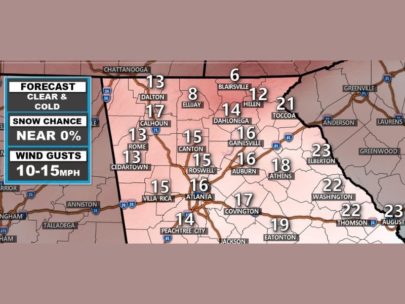
Wind Chills in the Teens and Single Digits Tuesday Morning
Forecast wind chill maps show widespread apparent temperatures in the 13–17 degree range across Atlanta, Rome, Canton, Calhoun, and surrounding areas. In higher elevations and northern counties—such as Blairsville and Dahlonega—wind chills may fall into the single digits, creating dangerous cold for early commuters.
Actual temperatures early Tuesday morning are expected to range from the upper teens to the upper 20s, but brisk winds will make it feel much colder. The dramatic difference between air temperature and wind chill highlights the severity of the incoming cold snap.
Residents are urged to dress in insulated layers, limit early-morning outdoor activity, and protect pets and exposed plumbing from the freezing conditions.
Cold Pattern Will Continue Through Midweek
Even after Tuesday morning’s brutal wind chills, temperatures will remain cold through midweek. Afternoon highs will gradually recover but stay below seasonal averages for most areas. The combination of chilly mornings and breezy afternoons will keep conditions uncomfortable longer than usual for early January.
As this significant cold blast impacts Georgia, NapervilleLocal.com will continue monitoring updated temperature trends, overnight lows, and changing wind conditions. Check back for more local and regional weather coverage as the state prepares for one of the coldest starts of the season.

I’ve lived in Naperville long enough to see how quickly our community changes — from new developments downtown to sudden shifts in our Midwest weather. Reporting on Naperville news and daily forecasts gives me the chance to keep neighbors informed about what really matters. My goal is simple: deliver clear, timely updates so you always know what’s happening in our city and what to expect from the skies above.