
Major Pattern Shift as High-Pressure Blocking Sets Up Potential for Bitter Cold and Above-Normal Snowfall in Mid-to-Late January
UNITED STATES — A dramatic shift in the upper-air pattern is unfolding as long-range models align on a major January pattern change that could open the door to widespread cold outbreaks and elevated snow potential across large portions of the United States. Meteorologists are closely monitoring a developing setup of high-pressure blocking that may significantly alter the jet stream during the second half of January.
While ensemble agreement does not guarantee precise storm outcomes, forecasters say the consistency across multiple long-range models is a strong indicator that a dominant cold-weather pattern is taking shape. The transition appears likely to develop within the next one to two weeks, marking a break from the milder stretches that closed out 2025.
Long-Range Models Agree on a Shift Toward a Colder, Storm-Friendly Pattern
Forecast reliability beyond seven days declines when predicting individual storms, but long-range pattern signals often emerge well before specifics can be pinned down. In this case, multiple global models — run hundreds of times in ensemble form — are now showing similar hemispheric signals pointing toward a colder, more active pattern.
Meteorologists note that such agreement across model suites is uncommon unless a large-scale shift is underway. If the pattern verifies, much of the continental U.S. could experience below-normal temperatures, more frequent storm systems, and increased snow chances during the second half of January.
These types of pattern reorganizations often precede periods of significant winter weather, especially when the jet stream becomes more amplified and allows Arctic air to penetrate deeper into the U.S.
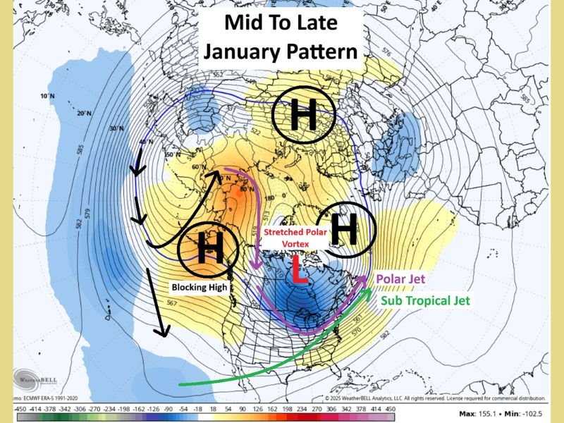
Three Key Blocking Highs Are Driving the Pattern Change
A primary component of the expected shift is the emergence of three major blocking areas of high pressure across the Northern Hemisphere. The most influential is a block expected to develop over Alaska, which would force the jet stream northward and allow bitter Arctic air to plunge southward into the United States.
Blocking highs tend to remain in place for extended periods — sometimes weeks — meaning once the new pattern locks in, it may persist through much of mid-January.
The second and third blocking highs, positioned near the Ural Mountains and Greenland, play additional roles by helping direct cold air masses toward North America and altering the pathways available for storm systems. This combination of blocking highs suggests a stretched or displaced polar vortex, a common feature during colder-than-normal winter stretches.
Jet Stream Split Could Increase Snow Potential
With strong blocking to the north, the jet stream may split into a northern polar branch and a southern subtropical branch. The southern branch is crucial because it carries moisture into the central and eastern U.S. If this moisture interacts with incoming Arctic air from the polar jet, the setup can produce high-impact winter storms.
Historically, mid-to-late January is already among the coldest and snowiest periods of the season. A pattern that enhances moisture flow while funneling polar air southward increases the probability of multiple snow events, though specific storm tracks cannot yet be forecast.
Meteorologists caution that predicting exact storm timing at this range is impossible, but the underlying ingredients appear favorable for significant winter activity.
Outlook: Colder Temperatures and Higher Storm Activity Likely
Forecasters emphasize that while no single storm can yet be identified, the evolving pattern strongly favors colder-than-normal temperatures and an uptick in storm frequency during the second half of January. Should the blocking pattern strengthen further, parts of the Midwest, Great Lakes, and Northeast may face prolonged cold spells and several winter weather systems.
Residents across Illinois and neighboring states should prepare for a more active winter period ahead, including the possibility of impactful storms. NapervilleLocal.com will continue monitoring model trends and provide updated forecasts as new data becomes available.

I’ve lived in Naperville long enough to see how quickly our community changes — from new developments downtown to sudden shifts in our Midwest weather. Reporting on Naperville news and daily forecasts gives me the chance to keep neighbors informed about what really matters. My goal is simple: deliver clear, timely updates so you always know what’s happening in our city and what to expect from the skies above.