
Ohio Braces for More Than a Foot of Lake-Effect Snow as Snowbelt Counties Face 12–18 Inches and Dangerous Whiteout Conditions Through Early Thursday
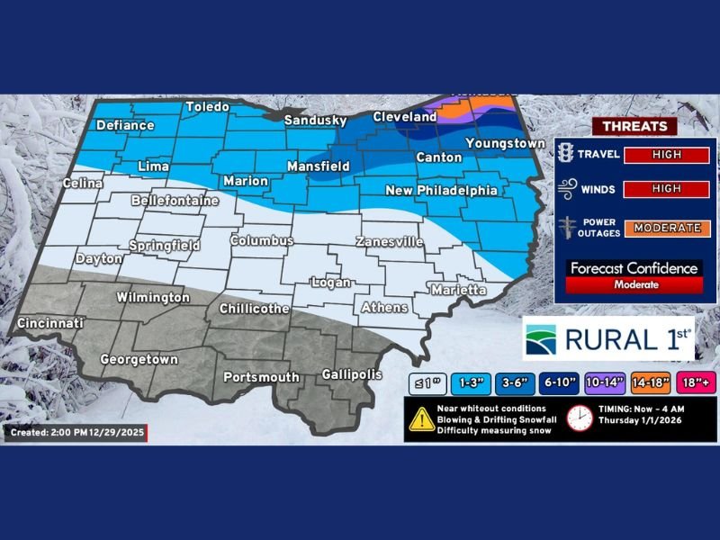
OHIO — A potent lake-effect snow event is intensifying across northern Ohio, with forecasters now projecting 12 to 18 inches of accumulation in the snowbelt east of Cleveland and major travel impacts lasting through early Thursday morning. Sharply colder air, multiple waves of low pressure, and ideal wind direction are combining to produce one of the most significant lake-effect snow setups of the season.
Meteorologists emphasize that snowfall will occur in multiple waves rather than all at once. Periods of heavy snow will be followed by temporary breaks lasting several hours before new bands re-develop and push inland again.
Snow Continues Through 4 AM Thursday With Breaks Between Heavy Bands
The lake-effect event is expected to continue through approximately 4 AM Thursday, though snowfall will not be continuous. Forecasters note the importance of understanding that these events operate in pulses. Snow bands may drop visibility to near zero for an hour or two, then shift or weaken, only to redevelop later in the night.
This pattern will persist as colder air deepens over Lake Erie and interacts with multiple troughs swinging through the region. The timing map reflects total snowfall expected through early Thursday morning, not snowfall occurring all at once.
Residents should anticipate rapidly changing road conditions, especially after sunset.
Snowbelt Counties Could See 12–18 Inches With Some Localized Maxima
Forecasts show significant snowfall exceeding 12 inches across much of the snowbelt. Parts of Geauga and Ashtabula counties could receive 14 to 18 inches of snow, with isolated totals potentially higher where persistent bands remain anchored over the same locations.
A clipper system arriving Wednesday night will add additional snow before reinforcing colder air moves in behind it. This creates a multi-layered storm setup that intensifies lake-effect production well into early Thursday. Outside the primary snowbelt, areas around Cleveland, Akron, Canton, and Youngstown may receive shovel-able snowfall, ranging from 3 to 6 inches depending on wind direction and band placement.
High Winds and Whiteout Conditions Likely Along I-90 Corridor
High winds will be a major contributor to hazardous conditions. Gusts will cause blowing and drifting snow, particularly along the Interstate 90 corridor, where visibility could drop suddenly due to whiteouts.
Travel is expected to be significantly impacted overnight and into Thursday morning. Difficult or impossible driving conditions may occur in areas experiencing narrow but intense snowbands. Forecasters strongly recommend delaying travel when possible until conditions stabilize.
Power outages are also a concern. Heavy lake-effect snow combined with strong winds may lead to downed branches, snow-coated lines, and temporary service interruptions.
Snow Outside the Snowbelt: Still Enough to Affect Roads
Although the heaviest snow remains locked into the snowbelt, communities outside the primary impact zone will still experience accumulating snowfall. Cities such as Columbus, Springfield, Zanesville, and Marion may see between 1 and 3 inches, enough to create slick spots and slow commutes.
Southwest Ohio, including Cincinnati and Wilmington, is expected to see little to no accumulation, as warmer air and distance from the lake limit snow production. Nonetheless, cold air will cover the entire region, keeping temperatures well below freezing through the event.
Residents Urged to Prepare for Hazardous Travel and Rapidly Changing Conditions
Officials advise residents in northern Ohio to prepare for prolonged periods of poor visibility, drifting snow, and road closures. Given the intense nature of lake-effect bands, conditions can deteriorate within minutes even in areas that appeared unaffected earlier.
NapervilleLocal.com will continue monitoring updated accumulation maps, band movement, and alerts from local authorities as this lake-effect event evolves. Check back for updated coverage as Ohio faces one of its strongest snowbelt events of the winter.

I’ve lived in Naperville long enough to see how quickly our community changes — from new developments downtown to sudden shifts in our Midwest weather. Reporting on Naperville news and daily forecasts gives me the chance to keep neighbors informed about what really matters. My goal is simple: deliver clear, timely updates so you always know what’s happening in our city and what to expect from the skies above.