
North Carolina Faces Statewide High Fire Danger as Dry Air, Strong Winds and Low Humidity Increase Wildfire Risk
NORTH CAROLINA — A widespread high fire danger has been issued across the entire state as fast-dropping humidity, gusty winds, and extremely dry conditions combine to create a rapidly escalating wildfire threat. While only a portion of North Carolina is under an official Red Flag Warning, the latest weather data shows that all counties face conditions capable of supporting fast-spreading fires through late tonight.
A strong cold front moving across the region this afternoon is playing a critical role in increasing the danger. Forecasters note that downslope winds behind the front will strengthen through the evening, bringing periods of gusty and unpredictable wind shifts. These winds, combined with already dry vegetation, mean that any small spark could expand into a rapidly spreading fire.
Dry Air and Dropping Humidity Fuel Dangerous Fire Conditions
One of the primary drivers of today’s elevated fire risk is the sudden drop in relative humidity. As the front moves southeast, humidity levels are expected to fall quickly, creating an atmosphere with very little moisture to slow or suppress fire activity. Dry air, especially when paired with gusty winds, allows flames to grow faster, jump between dry fuels, and spread over open areas with little resistance.
These conditions are especially concerning given the ongoing drought across much of the state. North Carolina remains in moderate drought, meaning the ground and vegetation are already stressed and highly susceptible to burning. This combination significantly increases the likelihood that any fire that starts could become difficult to control.
Strong Winds Make Fire Spread Even Faster Across All Regions
Wind is a leading factor in fire growth, and today’s pattern is producing strong downslope winds from the mountains into the Piedmont and coastal counties. These winds can push flames across fields, forests, and residential areas with little warning. Fire officials emphasize that gusts may increase during the late afternoon and early evening, creating the most dangerous window for fire activity.
Because winds can shift direction quickly behind the cold front, firefighters may also face unpredictable fire behavior. This instability further supports the recommendation that residents avoid all outdoor burning, even in areas where local regulations may normally permit it.
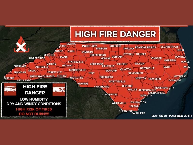
Entire State Under High Fire Danger Despite Partial Red Flag Warning
Although the National Weather Service has issued a Red Flag Warning for only part of North Carolina, the entire state is under high fire danger according to regional fire analysts. The color-coded fire risk map shows every county highlighted in red, indicating that no area is safe for open flames, debris burning, or outdoor fire pits.
Officials stress that residents should treat today as a “no burn” day statewide. Even routine activities—such as discarding cigarettes, using outdoor equipment that produces sparks, or burning small brush piles—could accidentally ignite a wildfire capable of spreading over a large area.
Residents Strongly Urged to Avoid Outdoor Burning Today
Emergency managers and weather authorities are urging all North Carolinians to postpone any outdoor burning until conditions improve. Because the fire danger will remain elevated until late tonight, burning during the afternoon or evening could still trigger a fast-moving fire, even in monitored settings.
As conditions continue to develop, NapervilleLocal.com will provide updates on changing fire risk levels and any fire-related alerts issued by state officials. Residents are encouraged to stay alert, follow local guidance, and use caution until winds weaken and humidity levels rise again. For ongoing weather updates and safety coverage, stay connected with NapervilleLocal.com.

I’ve lived in Naperville long enough to see how quickly our community changes — from new developments downtown to sudden shifts in our Midwest weather. Reporting on Naperville news and daily forecasts gives me the chance to keep neighbors informed about what really matters. My goal is simple: deliver clear, timely updates so you always know what’s happening in our city and what to expect from the skies above.