
Ohio Lake-Effect Snowstorm Intensifies Through Thursday Morning as Snowbelt Areas Face Over a Foot of Accumulation
Ohio — A prolonged and intensifying lake-effect snow event is underway across the state, with additional snowfall expected through Thursday morning, particularly across northern and northeastern Ohio’s Snowbelt regions. Weather data indicates that several communities could see major accumulations exceeding one foot, creating hazardous travel conditions and extended disruptions.
This system is being driven by persistent lake-effect bands combined with multiple reinforcing waves of snow, allowing snowfall to continue in rounds rather than tapering quickly. While lighter totals are expected farther south and west, Snowbelt counties are bracing for the most severe impacts.
Snowfall Timeline and Expected Accumulations
Scattered lake-effect snow has been ongoing, but impacts increase significantly as broader snowfall waves move through. During the evening hours, a widespread round of snow is expected to deliver 1 to 3 inches for most areas, adding to what has already fallen.
By Wednesday morning, persistent lake-effect bands across the Snowbelt will push totals toward 4 to 6 inches, even before the next round arrives. Wednesday afternoon and evening then bring another reinforcing wave of snow, again producing 1 to 3 inches statewide, with lake enhancement sharply increasing totals in primary and secondary Snowbelt zones.
In those Snowbelt areas, an additional 3 to 8 inches is possible Wednesday into early Thursday. Snow lingers into Thursday morning before gradually tapering off, allowing totals to stack rapidly in the hardest-hit locations.
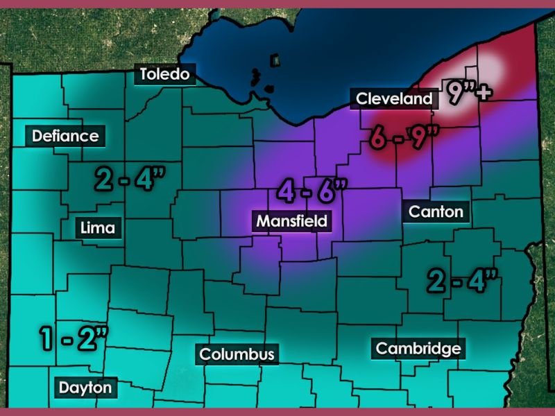
Which Areas Are Most at Risk
Snowfall projections show a sharp gradient across the state:
- Northern and Northeastern Ohio Snowbelt:
Communities near and east of Lake Erie are expected to see the highest totals, with 6 to 9 inches common and localized totals exceeding 12 inches possible. Some areas closer to the core lake-effect bands may surpass a foot. - North-Central Ohio:
Areas around Mansfield are forecast to receive 4 to 6 inches, with periods of moderate snowfall and reduced visibility. - Central, Western, and Southern Ohio:
Snowfall amounts decrease farther from the lake, with most locations seeing 1 to 4 inches, including areas near Columbus, Dayton, Lima, and Cambridge.
This sharp contrast highlights how lake-effect systems can produce extreme differences over short distances, especially when bands remain stationary.
Why This Lake-Effect Event Is So Impactful
Unlike quick-moving winter systems, this event is defined by persistence. Cold air flowing over the relatively warmer waters of Lake Erie is allowing snow bands to continuously redevelop and regenerate. Each passing wave reinforces snowfall rather than ending it, increasing the risk of major accumulations in Snowbelt communities.
This setup also raises the likelihood of frequent visibility drops, rapidly changing road conditions, and snow-covered surfaces that remain untreated for extended periods.
Travel and Safety Concerns
Travel conditions will be most dangerous in Snowbelt regions, where roads may become snow-covered within minutes during heavier bands. Even areas outside the Snowbelt could see slick conditions during peak snowfall periods Wednesday evening and overnight.
Drivers are urged to use caution, reduce speeds, and allow extra time if travel is unavoidable. Visibility can deteriorate rapidly in lake-effect bands, increasing the risk of accidents.
What to Expect Next
Snow will gradually diminish Thursday morning as lake-effect bands weaken and shift, but cleanup and lingering impacts are expected to continue through the day in heavily affected areas. Additional advisories or warnings may be issued as totals become clearer.
For continued coverage of major winter weather systems affecting the Midwest and surrounding regions, visit NapervilleLocal.com for ongoing updates, forecasts, and regional impact reports.

I’ve lived in Naperville long enough to see how quickly our community changes — from new developments downtown to sudden shifts in our Midwest weather. Reporting on Naperville news and daily forecasts gives me the chance to keep neighbors informed about what really matters. My goal is simple: deliver clear, timely updates so you always know what’s happening in our city and what to expect from the skies above.