
Texas and Oklahoma to See Increasing Rain and Storm Chances by Mid Next Week, Weather Pattern Shifts After a Dry Month
TEXAS — A more unsettled weather pattern is expected to return across Texas and Oklahoma by the middle of next week, bringing the first meaningful rain chances either state has seen in nearly a month. Forecast models show a noticeable uptick in rain and thunderstorm potential beginning Wednesday, with the most active period projected between January 7 and January 11.
Rain Returns After Weeks of Dry Conditions
Much of Texas and Oklahoma has gone through an extended stretch of dry weather, with some regions approaching 30 days without measurable rainfall. That pattern is now expected to break as a new system begins pushing moisture into the Southern Plains next week.
Early indications suggest daily rain or storm chances for several consecutive days, offering some much-needed relief to areas that have seen unusually persistent dryness for early winter.
Storm Activity Increasing Wednesday and Thursday
The most noticeable shift is expected to occur on Wednesday and Thursday, when widespread rain bands and scattered thunderstorms may develop from North Texas through central Oklahoma.
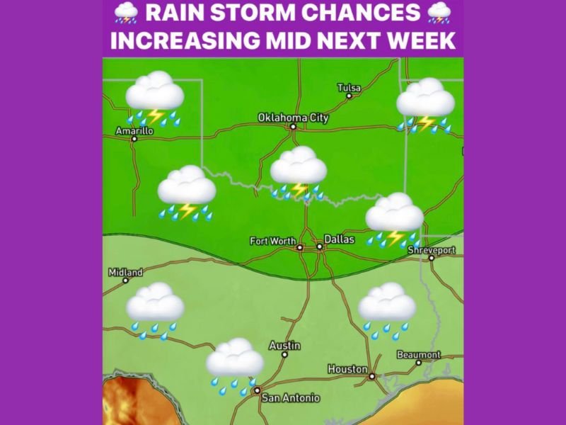
Cities that could see increased rainfall chances include:
- Dallas–Fort Worth
- Oklahoma City
- Tulsa
- Austin
- San Antonio
- Houston
- Shreveport region (east of Texas border)
While severe weather signals are not strongly highlighted yet, forecasters are watching for the possibility of isolated thunderstorms capable of locally heavier rainfall.
Moisture Expands Across Central and Southern Texas
As the pattern continues through late week, moisture spreads deeper into central and southern Texas. This includes areas like Austin, San Antonio, Beaumont, and the Hill Country. These regions are likely to experience steady light-to-moderate rain, with brief thunderstorms possible.
The pattern does not currently suggest major flooding or severe outbreaks, but after such a long dry stretch, even moderate rainfall may impact travel and outdoor plans.
Extended Window of Daily Rain Possibilities
From January 7 through January 11, models consistently show:
- Daily rain chances across portions of Texas and Oklahoma
- Embedded thunderstorms depending on daytime heating
- Cloudy and cooler conditions in many areas
- A break from the persistent dry air that dominated much of December
This window represents the most active weather stretch either state has seen in several weeks. For continued updates on next week’s developing rain and storm pattern, follow the latest coverage on NapervilleLocal.com.

I’ve lived in Naperville long enough to see how quickly our community changes — from new developments downtown to sudden shifts in our Midwest weather. Reporting on Naperville news and daily forecasts gives me the chance to keep neighbors informed about what really matters. My goal is simple: deliver clear, timely updates so you always know what’s happening in our city and what to expect from the skies above.