
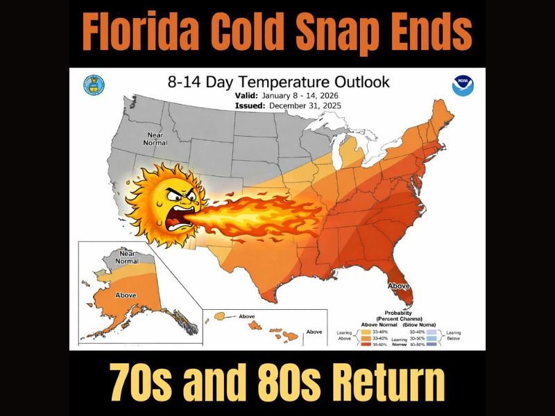
Florida Cold Snap Ending as Warmer Temperatures Return; 70s and 80s Expected by Mid-January, Says NWS Outlook
FLORIDA — After several days of unusually chilly conditions across the Sunshine State, a significant warmup is now on the horizon. According to the National Weather Service’s 8–14 Day Temperature Outlook, Florida is expected to transition out of its recent cold snap, with temperatures surging back into the 70s and even lower 80s between January 8 and 14, 2026.
Warmer Air Expanding Across the Eastern U.S.
Forecasters indicate that a broader warming trend will develop across much of the eastern United States. This shift in the upper-air pattern will allow above-normal temperatures to build from the Gulf Coast through the Southeast and up the Atlantic coast.
Florida sits in the highest probability zone for well-above-average warmth, making a return to typical winter comfort highly likely. The NWS outlook map shows a pronounced band of orange and red across the state, highlighting the strong confidence in a warming pattern.
Cold Snap Brought Unusual Lows
This warming trend comes as welcome news for residents who endured several mornings of near-freezing lows, especially in northern and central Florida. While brief cool spells are not uncommon in January, this recent cold stretch persisted longer than usual, creating notable drops in morning temperatures and widespread frost potential. The developing warm ridge will effectively end that pattern.
70s and 80s Expected Across Much of Florida
Beginning in the second week of January, temperatures are expected to rebound significantly:
- North Florida: Lower to mid-70s
- Central Florida: Upper 70s to low 80s
- South Florida: Lower 80s likely, with humidity increasing
Forecasters note that the warmth could feel even more pronounced compared to the recent chill, especially for those who struggled with cooler evenings and colder-than-normal mornings.
Warm Pattern May Persist Beyond Mid-Month
Meteorologists suggest this warm phase could extend beyond the official 8–14 day outlook window. While forecasts always adjust with new data, the strong signal of a southeastern ridge implies that above-normal temperatures may continue into the third week of January. This shift will also likely reduce the chance of frost events in the near future.
For ongoing weather developments and extended U.S. temperature outlooks, follow the latest updates on NapervilleLocal.com.

I’ve lived in Naperville long enough to see how quickly our community changes — from new developments downtown to sudden shifts in our Midwest weather. Reporting on Naperville news and daily forecasts gives me the chance to keep neighbors informed about what really matters. My goal is simple: deliver clear, timely updates so you always know what’s happening in our city and what to expect from the skies above.