
Sierra Nevada Braces for Major Winter Storm With Feet of Snow and 100 MPH Ridge Winds From Friday Through Monday
CALIFORNIA — A powerful winter storm system is set to hammer the Sierra Nevada beginning Friday, with forecasters issuing a Winter Storm Warning that extends through the weekend and into Monday. The storm is expected to deliver several feet of snow, dangerous mountain travel, and ridge-level wind gusts reaching 100 mph, creating one of the most significant early-year snow events for the region.
Heavy Snowfall Expected Across Sierra Elevations
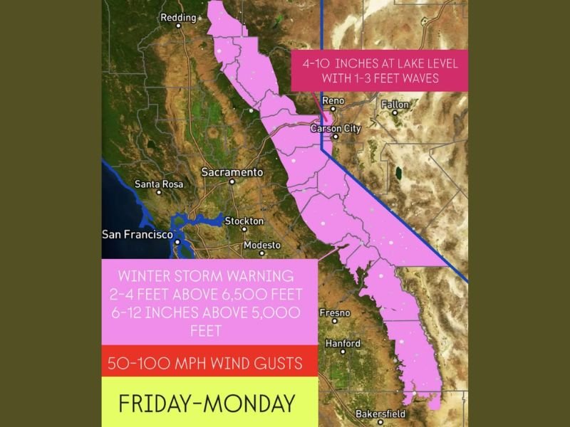
The strongest snowfall totals are expected above 6,500 feet, where the National Weather Service projects 2–4 feet of accumulation through Monday. Lower elevations above 5,000 feet may still receive 6–12 inches, enough to create hazardous road conditions, chain requirements, and extended travel delays along major Sierra passes such as Donner Pass, Echo Summit, Carson Pass, and Tioga areas.
Lake-level communities, including locations around Lake Tahoe, are expected to see 4–10 inches of snow, along with additional difficulties created by strong winds.
Damaging Winds Likely to Accompany the Storm
Forecasters warn that this storm system is not defined by snow alone. The Sierra ridgeline may experience wind gusts between 50 and 100 mph, conditions capable of blowing snow into whiteout conditions, toppling trees, and creating extensive drifting. Such winds significantly increase avalanche risk in backcountry zones and make mountain travel dangerous or impossible during peak intensity.
Lower elevations are also expected to feel the effects, with gusts up to 50 mph around Lake Tahoe and surrounding foothill communities. These winds may produce 1–3 foot waves on Lake Tahoe, leading to hazardous lake conditions and potential shoreline impacts.
Travel Will Become Extremely Hazardous
Transportation officials warn that anyone planning to travel through the Sierra from Friday through Monday should prepare for severe disruptions. Periods of zero visibility, heavy snowfall rates, strong crosswinds, and icy pavement will create conditions where travel may be delayed for hours or shut down entirely.
Interstate 80, Highway 50, Highway 88, and other mountain routes may experience intermittent closures, chain controls, or extended traffic holds. Even prepared vehicles may struggle against the combination of high winds and rapidly accumulating snow.
Storm Could Provide Vital Snowpack but Comes With Risks
While this system will deliver a much-needed boost to the Sierra snowpack—critical for California’s water supply—it will also bring risks associated with blowing snow, avalanche danger, tree damage, and potential power outages in elevated regions. The duration of the storm, spanning several days, increases the likelihood of cumulative impacts.
Residents, travelers, and winter recreationists are advised to monitor updated forecasts, avoid unnecessary travel during peak conditions, and prepare for rapidly changing weather throughout the weekend. Stay updated with the latest weather impacts affecting the region at NapervilleLocal.com.

I’ve lived in Naperville long enough to see how quickly our community changes — from new developments downtown to sudden shifts in our Midwest weather. Reporting on Naperville news and daily forecasts gives me the chance to keep neighbors informed about what really matters. My goal is simple: deliver clear, timely updates so you always know what’s happening in our city and what to expect from the skies above.