
Winter Weather Advisory Expanded Across Washington, Idaho, Montana, and Oregon as Ice and Snow Create Hazardous Travel Through Friday
PACIFIC NORTHWEST — A broad Winter Weather Advisory has been expanded across multiple states in the Pacific Northwest, with Washington, Idaho, Montana, and Oregon now under alert through Friday as a mix of freezing rain, accumulating snow, and ice threatens to create dangerous travel conditions. The advisory covers major population corridors, mountain passes, and rural roadways that are likely to face significant disruptions.
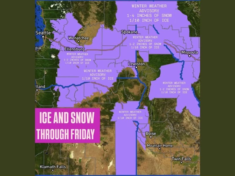
Snowfall Ranges From 1 to 4 Inches Across the Region
The National Weather Service reports that many areas included in the advisory will receive 1–4 inches of snow, with localized totals varying based on elevation and storm intensity. Cities such as Spokane, Wenatchee, Ellensburg, Lewiston, and Missoula fall under the advisory, each expecting periods of steady snow capable of producing slick and snow-covered roads.
Lower snow totals of 1–2 inches are forecast for portions of Idaho and Montana, while central Washington—including the Columbia Basin—may see a slightly wider range of totals due to shifting bands of precipitation. Even small snow accumulations can create travel hazards when paired with below-freezing temperatures and icy surfaces.
Ice Accumulations Pose the Greatest Travel Threat
While snowfall amounts will vary, forecasters emphasize that ice is the most dangerous component of this system. Much of the region under advisory is expected to receive around one-tenth inch of ice, enough to create glazed roadways, treacherous sidewalks, and difficult highway travel from Thursday night into Friday.
Ice accumulation on elevated road surfaces—such as bridges, overpasses, and mountain passes—can quickly turn hazardous, even with light precipitation. Drivers in affected regions, especially along major routes like I-90, U.S. 2, and U.S. 12, should anticipate reduced traction, sudden slick spots, and travel slowdowns. Conditions may worsen overnight as temperatures drop further, allowing untreated roads to become fully iced over.
Widespread Impacts Expected Across Four States
The advisory spans a large geographical area, affecting both rural communities and significant travel hubs. Areas including Boise, Mountain Home, Twin Falls, Klamath Falls, and the Bitterroot Valley are all included in regions experiencing freezing rain potential.
Mountain passes across the Cascades and northern Rockies will face low visibility, packed snow, icy pavement, and increased risk of spinouts, making non-essential travel risky. Aviation delays are also possible due to freezing precipitation and de-icing requirements. Authorities are urging residents to use caution, allow extra travel time, and avoid unnecessary driving during peak freezing rain periods.
Storm System Expected to Exit by Friday Afternoon
The winter weather system is forecast to gradually weaken by Friday afternoon, but lingering slick spots will remain a concern until temperatures rise above freezing. Road crews will continue treating highways, though rapid icing may temporarily outpace mitigation efforts. For ongoing updates on regional and national weather impacts, continue following NapervilleLocal.com.

I’ve lived in Naperville long enough to see how quickly our community changes — from new developments downtown to sudden shifts in our Midwest weather. Reporting on Naperville news and daily forecasts gives me the chance to keep neighbors informed about what really matters. My goal is simple: deliver clear, timely updates so you always know what’s happening in our city and what to expect from the skies above.