
Southern and Eastern U.S. States Brace for Unseasonable January Warmth as Temperatures Surge 10–20 Degrees Above Average January 6–8
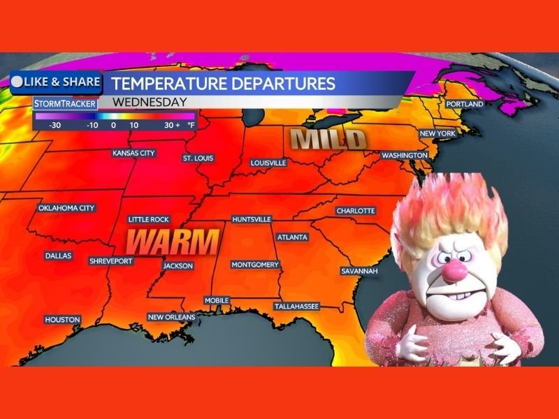
UNITED STATES – A significant mid-winter warm-up is expected across much of the United States east of the Rocky Mountains by the middle of next week, January 6 through January 8, with temperatures forecast to run 10 to more than 20 degrees above average for this time of year. According to the temperature departure map, the warmest anomalies will stretch from the Southern Plains through the Mississippi Valley and into the Southeast and Mid-Atlantic, while colder air remains locked well to the north.
January Thaw Sets Up Across the South and Southeast
Forecast guidance shows widespread above-normal temperatures dominating the South-Central and Southeastern states, including Texas, Oklahoma, Arkansas, Louisiana, Mississippi, Alabama, Georgia, Tennessee, and the Carolinas.
Across much of the Southeast, daytime highs in the 60s and 70s are expected to be common for most of the week, an unusual pattern for early January. Cities across the Gulf Coast and lower Mississippi Valley are highlighted in the warmest temperature departure zone, indicating some of the largest positive anomalies.
Mild Air Expands Into the Midwest and East Coast
The warming trend is not limited to the South. Milder-than-normal air will also spread northward into the Ohio Valley, Mid-Atlantic, and parts of the Northeast, including areas around Kentucky, Ohio, Pennsylvania, Virginia, New York, and New England.
While temperatures in these regions may not reach springlike levels, the data shows conditions trending noticeably milder than seasonal norms, reinforcing the idea of a temporary winter break.
Why the Warm Pattern Is Not Expected to Last
Despite the dramatic warmth, meteorologists caution that this is still mid-winter, and the pattern is unlikely to persist long-term. The coldest Arctic air remains positioned far to the north, temporarily preventing major cold intrusions, but that setup can change quickly later in January. The current configuration favors southerly flow and suppressed cold air, allowing warmth to dominate for several days before a more typical winter pattern potentially returns.
What This Means for Residents
For many areas east of the Rockies, this January thaw may bring:
- Reduced heating demand
- Snowmelt in colder regions
- Outdoor conditions more typical of early spring
- A short-lived pause in winter severity
However, residents are reminded that winter is far from over, and rapid pattern shifts remain possible as the month progresses. For continued updates on national weather trends and how they impact regions across the country, follow ongoing coverage from NapervilleLocal.com.

I’ve lived in Naperville long enough to see how quickly our community changes — from new developments downtown to sudden shifts in our Midwest weather. Reporting on Naperville news and daily forecasts gives me the chance to keep neighbors informed about what really matters. My goal is simple: deliver clear, timely updates so you always know what’s happening in our city and what to expect from the skies above.