
Texas and Oklahoma Face Sharp Temperature Reversal as Strong January Cold Front Arrives After Springlike Heat
TEXAS – An unusual stretch of spring- to summer-like heat has taken hold across the Southern Plains, with temperatures climbing into the 90s in parts of Texas, but forecast data shows this warmth will end abruptly as a strong cold front arrives next weekend, during the January 10–11 timeframe.
While a couple of weak cold fronts are expected to pass through in the coming days, they are not strong enough to significantly cool the region. The upcoming late-week front, however, is expected to bring a much more dramatic temperature drop, particularly across Texas and Oklahoma.
Springlike Warmth Dominates Before the Pattern Shifts
The current pattern has allowed unseasonably warm air to surge northward, making conditions feel more like spring or even early summer across much of Texas. This type of warmth is highly unusual for early January and is being driven by persistent southerly flow and a lack of strong cold air intrusions. According to the data shown, this warmth is temporary, with the atmosphere already signaling a significant pattern change.
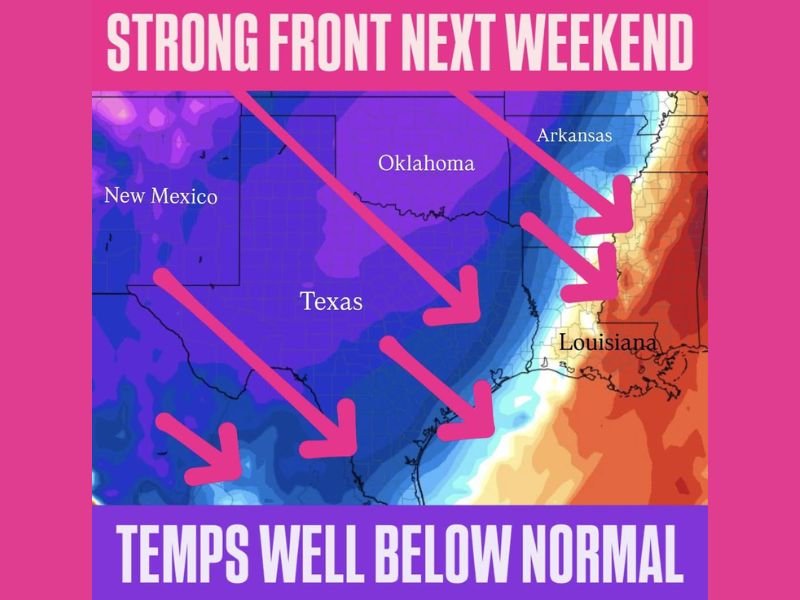
Stronger Cold Front Expected January 10–11
The image highlights a strong cold front moving south and east next weekend, with arrows indicating colder air pushing into Texas and Oklahoma. Behind this front, temperatures are expected to fall well below normal, ending the current warm spell. This front is notably stronger than the weaker systems preceding it and represents the first major cold push of the month for the Southern Plains.
Areas Most Impacted by the Temperature Drop
Based on the forecast graphic, the largest temperature swings are expected across:
- Texas, where highs currently near 90 degrees will fall sharply
- Oklahoma, which will also see a marked shift to colder-than-normal conditions
- Adjacent parts of the Southern Plains, as the cold air spreads southeastward
The color gradient shown on the map emphasizes a clear transition from warm to much colder air, especially across central and eastern Texas.
Why the Shift Matters
Rapid temperature drops following extended warmth can have real-world impacts, including stress on infrastructure, agriculture, and travel conditions. While the image does not indicate winter precipitation, the abrupt nature of the cooling is the primary concern.
Forecasters emphasize that this is still winter, and swings like this are typical when stronger cold fronts finally break through prolonged warm patterns. For continued updates on national and regional weather shifts, and clear explanations of what forecast changes mean, follow ongoing coverage from NapervilleLocal.com.

I’ve lived in Naperville long enough to see how quickly our community changes — from new developments downtown to sudden shifts in our Midwest weather. Reporting on Naperville news and daily forecasts gives me the chance to keep neighbors informed about what really matters. My goal is simple: deliver clear, timely updates so you always know what’s happening in our city and what to expect from the skies above.