
Washington and Oregon Cascades Face Major Mountain Snowstorm With Up to 4 Feet of Snow Impacting Passes Through Thursday
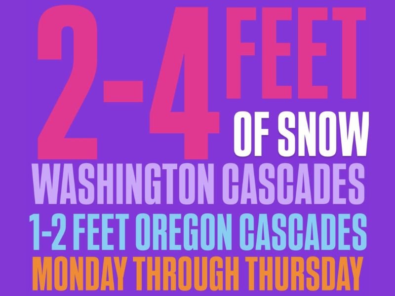
WASHINGTON – A major winter storm is expected to bring significant snowfall to the Cascade Mountains this week, with mountain passes facing dangerous travel conditions as snow accumulations reach extreme levels. Forecast data shows 2 to 4 feet of snow possible in the Washington Cascades, while the Oregon Cascades could see 1 to 2 feet of snow between Monday and Thursday.
The storm is expected to unfold over several days, increasing the risk of pass closures, chain restrictions, and hazardous driving conditions across higher elevations. Officials and travelers are urged to prepare for rapidly changing conditions as snow continues to pile up through midweek.
Snow Totals Point to Serious Travel Disruptions
According to the forecast graphic, snowfall amounts will vary by location, with the heaviest accumulations expected in higher elevations. The Washington Cascades are forecast to receive between 2 and 4 feet of snow, placing mountain corridors under prolonged winter stress. Meanwhile, 1 to 2 feet of snow is expected across the Oregon Cascades, enough to significantly impact travel and infrastructure.
Because the snow is spread across multiple days, road crews may struggle to keep mountain routes clear, especially during periods of heavier snowfall.
Mountain Passes Will Be Significantly Impacted
The image specifically warns that mountain passes will be significantly impacted, signaling difficult or potentially unsafe travel conditions. Snow-covered roads, reduced visibility, and the possibility of temporary closures are all concerns as the storm persists through Thursday.
Drivers traveling through the Cascades should expect slow travel, traction requirements, and possible delays, particularly during overnight and early morning hours when snowfall rates may intensify.
Timing and Duration Increase Risk
The storm is expected to begin early in the week and continue from Monday through Thursday, allowing snow totals to steadily accumulate. Prolonged snowfall events like this often increase the risk of avalanches in backcountry areas and place added strain on transportation routes that cross higher elevations.
With snow continuing over several days, conditions may deteriorate even if individual snowfall periods appear manageable.
Safety and Preparation Urged
Travelers are encouraged to monitor road conditions closely, carry winter safety supplies, and avoid unnecessary mountain travel if possible. Those planning trips through the Cascades should be prepared for rapidly changing weather, limited visibility, and extended delays. NapervilleLocal.com will continue tracking significant winter weather events across the country and provide updates as conditions evolve.

I’ve lived in Naperville long enough to see how quickly our community changes — from new developments downtown to sudden shifts in our Midwest weather. Reporting on Naperville news and daily forecasts gives me the chance to keep neighbors informed about what really matters. My goal is simple: deliver clear, timely updates so you always know what’s happening in our city and what to expect from the skies above.