North Carolina Sees “Fake Spring” Conditions as Fog Gives Way to Sunshine and Widespread 60s and 70s
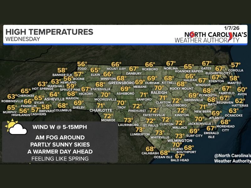
NORTH CAROLINA — A mild, spring-like weather pattern is unfolding across North Carolina on Wednesday, bringing above-average temperatures, early-morning fog, and partly sunny skies statewide, according to the latest forecast data.
Morning cloud cover and fog lingering in some areas are expected to gradually clear, allowing temperatures to climb well into the 60s and low 70s across much of the state. While a few locations may stay slightly cooler where clouds persist longer, overall conditions point to one of the mildest days residents have seen in recent weeks.
Foggy Start Followed by Clearing Skies
Forecast data shows areas of fog and low clouds during the morning hours, particularly in valleys and low-lying regions. As the day progresses, skies are expected to turn partly sunny, helping temperatures rise steadily through the afternoon. Winds will remain light from the west at around 5 to 15 mph, aiding in the gradual clearing of fog and clouds.
Temperatures Well Above January Normals
High temperatures across North Carolina are forecast to range from the mid-60s in cooler mountain locations to the low and mid-70s across central and eastern parts of the state.
Cities including Raleigh, Durham, Fayetteville, Wilmington, and Charlotte are expected to reach near or above 70 degrees, making conditions feel more like early spring than mid-winter. Meteorologists note that these readings are well above seasonal averages for early January, reinforcing the “fake spring” feel many residents will notice.
Not Everyone Will Be Equally Warm
While most of the state enjoys mild conditions, areas where fog or cloud cover lingers longer into the day could see slightly cooler temperatures. This includes some higher-elevation and western locations, where highs may stay in the upper 50s to low 60s. Even in those areas, conditions will still be noticeably milder than recent days.
A Brief Taste of Spring, Not a Pattern Shift
Despite the warm feel, this setup does not signal a permanent shift into spring. Forecast trends suggest this is a temporary warm stretch, common during winter transitions, rather than a long-term change in seasonal weather.
Residents are encouraged to enjoy the mild conditions while remaining prepared for typical winter variability in the days ahead. Stay with NapervilleLocal.com for continued regional weather updates, temperature trends, and clear explanations of changing conditions across the country.

I’ve lived in Naperville long enough to see how quickly our community changes — from new developments downtown to sudden shifts in our Midwest weather. Reporting on Naperville news and daily forecasts gives me the chance to keep neighbors informed about what really matters. My goal is simple: deliver clear, timely updates so you always know what’s happening in our city and what to expect from the skies above.

